SK - 2025: Country Fiche
Table of Contents
Introduction
The INSPIRE Directive sets the minimum conditions for interoperable sharing and exchange of spatial data across Europe as part of a larger European Interoperability Framework and the Data Spaces announced by the European Data Strategy from 20/02/19 and the e-Government Action Plan that contributes to the Shaping of Europe’s digital future Digital Single Market Agenda. Article 21 of INSPIRE Directive defines the basic principles for monitoring and reporting. More detailed implementing rules regarding INSPIRE monitoring and reporting have been adopted as Commission Implementing Decision (EU) 2019/1372 on the 19th August 2019.
This country fiche highlights the progress in the various areas of INSPIRE implementation. It includes information on monitoring 2024 acquired in December 2024 and Member States’ update.
State of Play
The following paragraphs provide a summary of currently valid information on governance, use, impacts and progress achieved towards INSPIRE implementation.
Coordination
National Contact Point
- Name of Public Authority: Ministry of Environment of the Slovak Republic
- Postal Address: Tajovského 28, 975 90 Banská Bystrica, Slovakia
- Contact Email: inspire@enviro.gov.sk
- Telephone Number: +421 48 4374 523
- National INSPIRE Website: https://inspire.gov.sk/
- MIG Contacts:
- Contact Person: Martin Tuchyna
- Email: martin.tuchyna@enviro.gov.sk
- Telephone Number: +421 48 4374 523
- Contact Person: Martin Koska
- Email: martin.koska@enviro.gov.sk
- MIG T Contacts:
- Contact Person: Martin Tuchyna
- Email: martin.tuchyna@enviro.gov.sk
- Telephone Number: +421 48 4374 523
- Contact Person: Martin Koska
- Email: martin.koska@enviro.gov.sk
Coordination Structure & Progress:
Coordination structure
Slovakia has transposed the INSPIRE Directive since 2010 by adopting a Law no. 3/2010 Coll. about the national infrastructure for spatial information, that was updated in 2016 and 2024. This legal act mandates the Ministry of Environment of the Slovak republic to coordinate the INSPIRE on national level. In addition Decree no. 352/2011 Coll., which implements some provisions of Act no. 3/2010 Z. z. on the national infrastructure for spatial information has been adopted in 2011 and updated in 2017.
Coordination of the relevant stakeholders in Slovakia is facilitated on two main levels:
- Strategy / Main public sector stakeholders’ level represented by the Coordination Committee of National Spatial Data Infrastructure NSDI Council / KR-NIPI
- Technical / implementation level represented by Expert Group of NSDI / ES NIPI
Considering the experience simplification of the governance framework has been initiated during the 2024 by the new NSDI Coordination group (KS NIPI) has been established based on Decision of the Minister of the Environment of the Slovak Republic No. 28/2024-1.16.1 on the Establishment of the Coordination Group for the National Spatial Data Infrastructure. KS NIPI is composed by the wide range of stakeholders from the public and private sector, academia as well as regional authorities or research and academia.
The Ministry of Environment of the Slovak Republic is also in charge of development and maintenance for National Geoportal, Spatial Data Registry as well as National INSPIRE website, communication with the Slovakian stakeholders, communication with European Commission, and provides the primary contacts in both Maintenance and Implementation Groups (MIG) political (MIG-P) and technical (MIG-T).
During the year 2024, coordination with Open Data / HVD community has continued. Main responsibility for the eGov / Open Data agenda remains with Ministry of investment, regional development and informatization of the Slovak Republic (MIRRI) (Figure 1.).
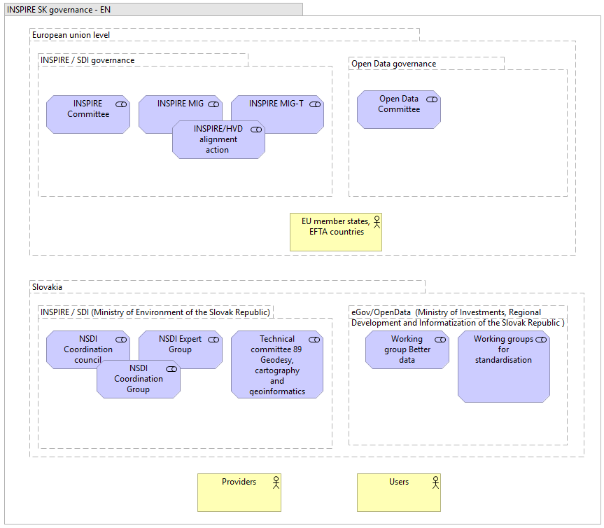
Figure 1: Overview of the Slovakian NSDI coordination
Progress
INSPIRE in Slovakia during the 2024 was mainly focused on the High Value Datasets support.
With that in mind relevant EU initiatives were closely followed and coordination with the relevant stakeholders, took place in order to ensure fulfillment of the related legal obligations and practical recommendations. New versions of the Spatial Data Registry (SDR) was launched during the 2024, providing the views on the High Value Datasets (HVD) identified on national level from the National spatial data infrastructure perspective SK NSDI HVD @ SDR.
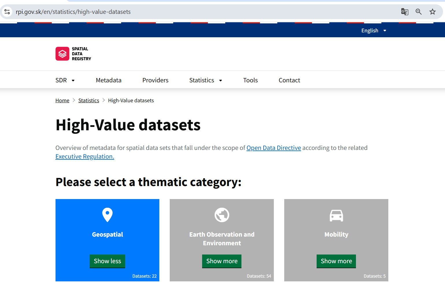
Figure 2: SK High value datasets from NSDI
Based on coordination with the MIRRI as well as responsible data providers, significant amount of HVD was successfully harvested into the SK National Open Data Portal as well as to the European Open Data portal European Open Data portal. These results were achieved thanks to the fulfillment of automated integration between SK NSDI metadata catalogue SDR and SK National Open Data portal utilising the DCAT-AP standard.
In order to strenghteen the knowledge transfer and networking Joint Czech and Slovak INSPIRE and Copernicus conference was organised in Slovakia (20. – 21. November 2024).
Main challenges remains with the conformity of spatial data sets towards the requirements for interoperability as well as with the conformity of some types of network services. Complexity of the INSPIRE requirements as well as limited capacities on the side of data providers still creates significant limitations. This remains even more tangible towards the regional and local SDIs.
Functioning and coordination of the infrastructure
Formal coordination of the NSDI during the 2024 was reduced, whilst preparing new simplified coordination framework. Further coordination took place mainly via bilateral interactions and with support of GitLab collaborative platform.
In connection the results of the INSPIRE monitoring 2024, there has been ensured continuing increase trend in most of the monitored indicators, thanks to continuos support to stakeholders and their commitment, including the support from EC INSPIRE Team.
Although most indicators remained stable, an increasing trend was observed in the areas of:
- Number of metadata for spatial data sets for the national level
- Number of metadata for spatial data sets for the regional level
- Compliance with interoperability requirements for spatial data sets for the topics in Annex II of the INSPIRE Directive
The Slovak Republic was also identified as a country representing examples of good practice in the areas of:
- Effective use of the INSPIRE reference validator
- Overall improvement of indicators in the interannual period 2023-2024
At the same time, areas requiring attention and improvement were identified (e.g. Declaration of compliance with interoperability requirements, simplification of data and service interconnection and metadata reduction, quality of services).
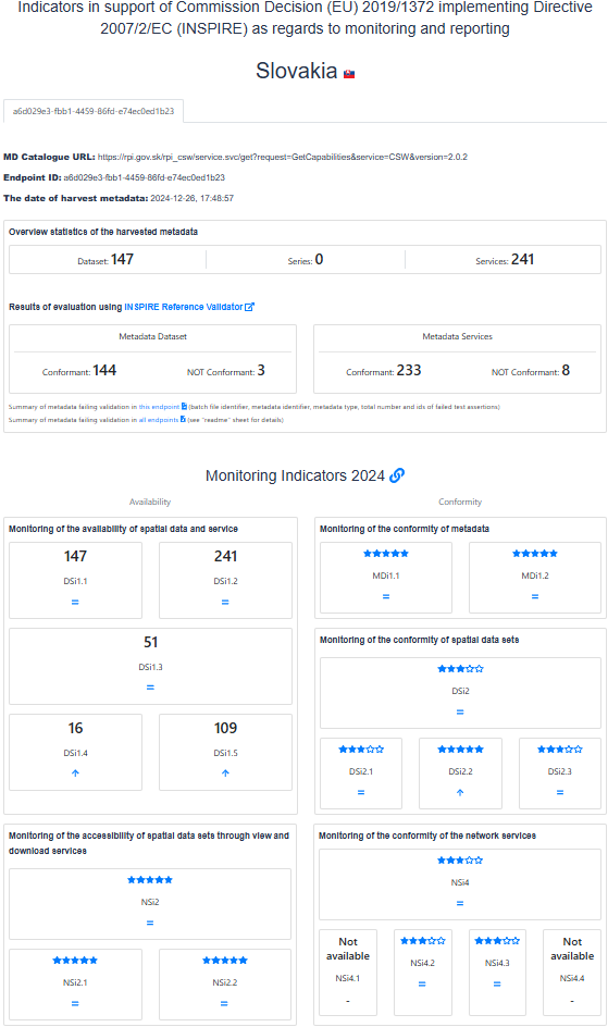
Figure 3: INSPIRE monitoring indicators 2024 - Slovakia
Usage of the infrastructure for spatial information
Systematic NSDI usage monitoring is slowly improving, but obtaining a satisfactory overview remains a challenge.
In 2024 monitoring of the resources in the NSDI was increased with extension of the monitoring and visualisation of the Network services availability via National Geoportal on the level of:
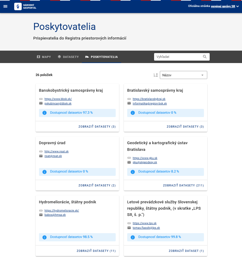
Figure 4: SK Monitoring of datasets availability on the level of Providers
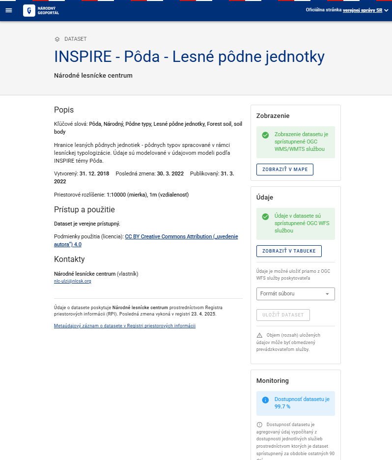
Figure 5: SK Monitoring of datasets availability on the level of datasets
There are also some indirect indicators providing related information. Google analytics statistics related to the INSPIRE related websites for 2024:
- geoportal.gov.sk: 0,3k users, 10k events;
- rpi.gov.sk: 7,1k users, 77k events;
- inspire.gov.sk: 9,5k users, 231k events.
Data Sharing Arrangements
Most of the INSPIRE datasets have been made available under the open data licence limiting possible restrictions for the further re-use. Some exceptions remain.
Adoption of HVD regulation contributed to the further discussion about the geospatial datasets to be made available under Open Data license and in synergy with INSPIRE.
Costs and Benefits
The cost and benefits evaluation is based on the information collected in the structured tabular information from the representatives of the relevant stakeholders.
The total indicative costs related with the INSPIRE implementation for 2024: 433 360 € and 410 person days.
From the Benefits perspective, these were identified mainly in for of • Ensuring legislative requirements of INSPIRE / NSDI, Open Data / HVD, and environmental reporting • Strengthening the discoverability of spatial data • Improving the availability of spatial data • Increasing the potential for re-use of digital spatial content and functionalities • Improving the results of INSPIRE monitoring for Slovakia • Strengthening communication with external domains and communities • Raising awareness of the potential of spatial data and services • Unified approach to spatial data (priority/harmonized datasets) • More efficient management and functionality of internal spatial data, services, and metadata • International cooperation (EuroGeographics – Open Maps for Europe Project)
Detailed information about the costs and benefits can be accessed via this summary table. Details, based on the information provided by the organisations.