RO - 2025: Country Fiche
Table of Contents
Introduction
The INSPIRE Directive sets the minimum conditions for interoperable sharing and exchange of spatial data across Europe as part of a larger European Interoperability Framework and the e-Government Action Plan that contributes to the Digital Single Market Agenda. Article 21 of INSPIRE Directive defines the basic principles for monitoring and reporting. More detailed implementing rules regarding INSPIRE monitoring and reporting have been adopted as Commission Implementing Decision (EU) 2019/1372 on the 19th August 2019.
This country fiche highlights Romania’s progress in the various areas of INSPIRE implementation. It contains information covering the period January to December 2024.
State of Play
The following paragraphs provide a summary of currently valid information on governance, use, impacts and progress achieved towards INSPIRE implementation.
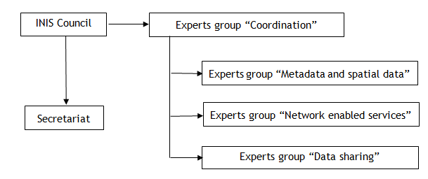
Coordination
National Contact Point
- Name of Public Authority: Ministry of Development, Public Works and Administration - National Agency for Cadastre and Land Registration
- Postal Address: 202A, Splaiul Independenței St., 1st floor, Sector 6, Bucharest
- Contact Email: inspire@ancpi.ro
- Telephone Number: +40 21 317 73 39
- Telefax Number: +40 21 316 52 24
-
National INSPIRE Website: www.geoportal.gov.ro
- Contact person: Laurențiu-Alexandru BLAGA
-
Email address: office@ancpi.ro
- Contact person - substitute: Constantin ENE
-
Email address: constantin.ene@ancpi.ro
- MIG Contacts:
- Contact Person: Ioan-Laurențiu RĂILEANU
- Email: ioan.raileanu@ancpi.ro
-
Telephone Number: +40 735 950 587
- Contact Person: Victor MINCHEVICI
- Email: victor.minchevici@mmediu.ro
- MIG T Contacts:
- Contact Person: Laura BOLOCAN
- Email: laura.bolocan@ancpi.ro
-
Telephone Number: +40 740 657 710
- Contact Person: Vasile CRĂCIUNESCU
- Email: vasile.craciunescu@meteoromania.ro
Coordination Structure & Progress:
Coordination structure
The INSPIRE Directive was transposed at national level by Government Ordinance No.4/2010 on the establishment of the National Infrastructure for Spatial Information (INIS) in Romania and has an essential role for Romania, as it lays the foundations for access and exchange of spatial data at national and European level, through the INIS geoportal of Romania and the INSPIRE geoportal of the European Union. In order to coordinate the realization and updating of INIS, the Council of the National Infrastructure for Spatial Information, hereinafter referred to as INIS Council, operates in Romania as a structure without legal personality, consistng of representatives of 21 public authorities listed in Annex no. 4 to this Ordinance. Also the general framework required for public authorities to fulfill their responsibilities is provided by Government Decision No. 579/2015 on establishing the specific responsibilities of public authorities and technical structures for the realization of spatial data themes and approving the necessary measures for their sharing. The Presidency and Secretariat of the INIS Council are provided by the National Agency for Cadastre and Land Registration (ANCPI), while the Vice-Presidency is provided by the Ministry of Environment, Water and Forests. As shown above, the INIS Council is assisted in its work by 4 expert groups.
Progress
The expert groups have continued their specific work to support public authorities in the implementation of INSPIRE. On the INIS geoportal of Romania, www.geoportal.gov.ro, information about the National Infrastructure for Spatial Information in Romania is available, providing access for the public and private sector users.
Improvements were observed in the data exchange compared to the previous year. This is also due to the fact that the spatial data infrastructure is constantly being updated. Analysing the results of the monitoring process of spatial data sets and services for the year 2024, there is an increase in the indicators regarding the monitoring of the metadata compliance for the data sets, in the accessibility of the spatial data sets through view and download services, and a stagnation of the indicators regarding monitoring the compliance of spatial data sets, the availability of spatial data and services, and the compliance of network services.
Functioning and coordination of the infrastructure
The National Agency for Cadastre and Land Registration (ANCPI) monitors the implementation and use of INIS and makes the results of this monitoring permanently accessible to the European Commission and the public. It is the public authority responsible for the realization of 7 themes (I.1 Reference coordinate systems, I.2 Geographic grid systems, I.4 Administrative-territorial units, I.5 Addresses, I.6 Cadastral parcels, III.2 Buildings and III.6 Public utilities and other public services) and a participating public authority in the realization of 11 themes. Unlike the other themes, the themes I.1 Reference Coordinate Systems and I.2 Geographic Grid Systems, do not refer to datasets accessible through download services, but present a basic functionality that allows harmonized and interoperable geographic localization of spatial objects defined in other INSPIRE themes. These themes are currently also available for visualization within the INIS geoportal, after a prior search in the Metadata Catalog. During the year 2024 ANCPI continues the action of collecting spatial data sets from regional water and sewerage operators, for the realization of spatial data services, in the specific format of INSPIRE Technical Standards, according to Theme III.6 Utilities and other public services. ANCPI has also undertaken measures on the interoperability of the data.gov.ro portals (the national open data portal) and the INIS geoportal of Romania in the scope of INSPIRE with regard to the list of high value datasets and persistent links to the licensing conditions and APIs that provide access to these datasets.
The Ministry of the Environment, Water and Forests (MMAP) which includes also its subordinated authorities, under its authority or under its coordination is the public authority responsible for the realization of 10 themes (I.8 Hydrography, I.9 Protected areas, III.7 Environmental monitoring facilities, III.8 Production and industrial facilities, III.11 Management/restriction/regulation zones and reporting units, III.17 Biogeographical regions, III.18 Habitats and biotopes, III.19 Species distribution, III.13 Atmospheric conditions and III.14 Meteorological geographical features) and public authority participating in the implementation of 19 spatial themes.
During 2024 MMAP has carried out the INSPIRE datasets update and publication services project, publishing on the national geoportal (INIS) and implicitly on the European INSPIRE geoportal 3 new datasets, (Romania Birds Distribution Dataset (art.12) - sensitive, Romanian Species Distribution Dataset (art.17) - sensitive and Romanian Species Range Dataset (art.17) - sensitive) each having both INSPIRE compliant visualization and download services, corresponding to theme III.19 Species Range. As they are sensitive data they are not available for download with free right of re-use and open access. The remaining datasets published in previous years, corresponding to INSPIRE themes I.9 - Protected Areas, III.17 - Biogeographical Regions and III.18 - Habitats and Biotopes and III.19 - Species distributions which are available through the European INSPIRE geoportal, can be downloaded with free right of re-use and with free and open access both from the Romanian INIS geoportal (geoportal.gov.ro) and from the national open data portal (www.data.gov.ro), being high value datasets according to the Commission Implementing Regulation (EU) 2023/138 establishing a list of specific high value datasets and the arrangements for their publication and re-use.
MMAP has developed part of the national datasets related to the INSPIRE III.5 Human Health and Safety and I.7 Transport Networks themes, which are priority datasets for e-reporting on Directive 2002/49/EC relating to the assessment and management of environmental noise. These are: DF1_5 AgglomerationSource GeoPackage, DF1_5 Major Airports GeoPackage, DF1_5 Major Roads Noise Sources and DF1_5 MajorRailway Source GeoPackage, they can be visualized as well as downloaded from both the European INSPIRE geoportal and the Romanian INIS geoportal (https://geoportal.gov.ro/metadata_manager_v2/#searchPanel) It is expected that all datasets will be available by July 2025, when including the National Road Infrastructure Management Company SA will finalize the strategic noise maps. Also, for the spatial data set related to INSPIRE theme III.5 Human Health and Safety and for four spatial data sets related to theme I.7 Transportation Networks, the MMAP has developed network services to be made available in the European INSPIRE geoportal through the Romanian INIS geoportal (geoportal.gov.ro), datasets that can be downloaded with free right of re-use and with free and open access on the national open data portal (www.data.gov.ro), which are also specific high value datasets.
The Ministry of Agriculture and Rural Development through the Agency for Payments and Intervention for Agriculture (APIA) is the public authority responsible for the realization of a theme III.9 Agricultural and aquaculture facilities . In 2024 APIA updated the information on the portal for the LPIS 2024 dataset and finalized the download services for the Orthoimages, Agricultural and Aquaculture Facilities datasets respectively for LPIS 2024. Also the INSPIRE search service of the APIA-MADR geo-portal has been federated with the INIS geo-portal of Romania, in the geo-portal version supporting the latest metadata version TG 2.0. Following APIA’s participation in international working meetings under the patronage of the European Commission / DG AGRI in 2021, one of the goals being “Romania’s process in sharing IACS data in INSPIRE using the AGRI-FOOD data portal, it was decided to pool the “LPIS” and “ZIE” datasets and implicitly to realize INSPIRE compliant metadata and visualization services and to manage INSPIRE non-compliant spatial datasets for the “LPIS” and “ZIE” datasets. During 2025 it is envisaged:
- update of the Agricultural and Aquaculture Facilities dataset related to the Register of Aquaculture Units.
- updating the LPIS dataset held by APIA;
- improvement of the download services by adding new functionalities in order to facilitate the retrieval of information by all interested entities.
- development of new applications within the geoportal, in line with the current and future rules developed by the European Commission related to the INSPIRE Directive, the integration and harmonization of new spatial datasets that may be introduced in the future in the INSPIRE Directive or other high value datasets according to the Open Data and Re-use of Public Sector Information Directive of 20.06.2019, transposed into national law by Law No. 179/09.06.2022 or other directives that will be issued during the current year.
### Usage of the infrastructure for spatial information
The public authorities in Romania download from the INIS geoportal, the INSPIRE compliant dataset related to the theme I.4 “Administrative Units”, based on an open data license. In order to avoid overlaps of spatial data public procurement and multiplication of the costs for collecting spatial data, it was created in the INIS geoportal, the National Projects application, which aims to record projects that produce spatial data financed from public funds, by uploading the project coverage area, followed by filling in the information related to the project. At the time of drafting this document, projects from 5 public authorities were uploaded. The spatial data under theme III.12 ”Natural risk zones” were used in the specific activities of local public authorities.
Data Sharing Arrangements
The public authorities in Romania conclude collaboration protocols to share the spatial data they hold. This includes not only the INSPIRE data, but also the spatial data that belong to the national infrastructure in Romania. Spatial data in national format, within the Download Applications within the INIS geoportal shall be provided on the basis of open licenses.
Costs and Benefits
Responses from national public authorities show that the realization of INSPIRE-compliant data sets and services often exceeds the existing technical and operational capacity of the institution. The INIS geoportal facilitates the discovery of data for the development of which common standards have been used to enable interoperability between public authorities and Member States, as well as sharing and reuse of data using a common infrastr According to Commission Implementing Regulation (EU) 2023/138 establishing a list of specific high-value data sets and the arrangements for their publication and re-use, it was found that of the 34 INSPIRE themes, established in the annexes I, II and III of Directive 007/2/EC, 27 themes contain high-value datasets belonging to the fields: geospatial, Earth observation and environment, meteorological and mobility, fields defined under Directive (EU) 2019/1024 2019 on open data and reuse of public sector information. Thus, the implementation of INSPIRE represents a considerable benefit for the implementation of the Open Data Directive.