LT - 2025: Country Fiche
Table of Contents
Introduction
This country fiche highlights Lithuania’s progress in the various areas of INSPIRE implementation. It contains information covering the period up to March 2025.
Lithuania has transposed the INSPIRE Directive into national law by adopting amendments to the Law on Geodesy and Cartography (https://e-tar.lt/portal/lt/legalAct/TAR.EFE69222D6BC/asr).
This law defines the Lithuanian spatial information infrastructure. Centralised spatial data sharing tools have been established on the Lithuanian Spatial Information Portal https://www.geoportal.lt/. The content of the Lithuanian Spatial Information Portal is available in Lithuanian and English.
The Lithuanian responsible authorities shall ensure the provision of spatial data sets included in the list approved by the Resolution of the Government of the Republic of Lithuania No 1460 of 13 October 2010 “On the approval of the spatial data themes of the Lithuanian Spatial Information Infrastructure” (https://e-tar.lt/portal/lt/legalAct/TAR.63D65F3568A2/asr) as well as of their metadata, to the INSPIRE geoportal of the European Commission (https://inspire-geoportal.ec.europa.eu); Lithuania ensures the functioning of the Lithuanian Spatial Information Infrastructure tools and provision of spatial data and services to the INSPIRE geoportal in Lithuania. The national INSPIRE data system is accessible at: https://www.inspire-geoportal.lt/geonetwork/srv/eng/catalog.search#/home.
State of Play
The following paragraphs provide a summary of currently valid information on governance, use, impacts and progress achieved towards INSPIRE implementation in Lithuania.
Coordination
National Contact Point
- Name of Public Authority: Ministry of Environment of the Republic of Lithuania
- Postal Address: A. Jakšto g. 4, 01105 Vilnius, Lithuania
- Contact Email: info@am.lt
- Telephone Number:+ 370 669 52682
- Telefax Number:
- National INSPIRE Website :https://www.inspire-geoportal.lt/geonetwork/srv
- MIG Contacts:
- Contact Person: Aušra Kalantaitė
- Email: ausra.kalantaite@am.lt
- Telephone Number:+370 669 52682
- Contact Person: Saulius Urbanas
- Email: saulius.urbanas@am.lt
- MIG T Contacts:
- Contact Person: Aurelija Šturaitė
- Email: aurelija.sturaite@ssva.lt
- Contact Person: Inga Andriuškevičiūtė
- Email: inga.andriuskeviciute@ssva.lt
- Telephone Number: +370 700 15100
Coordination Structure & Progress:
Coordination structure
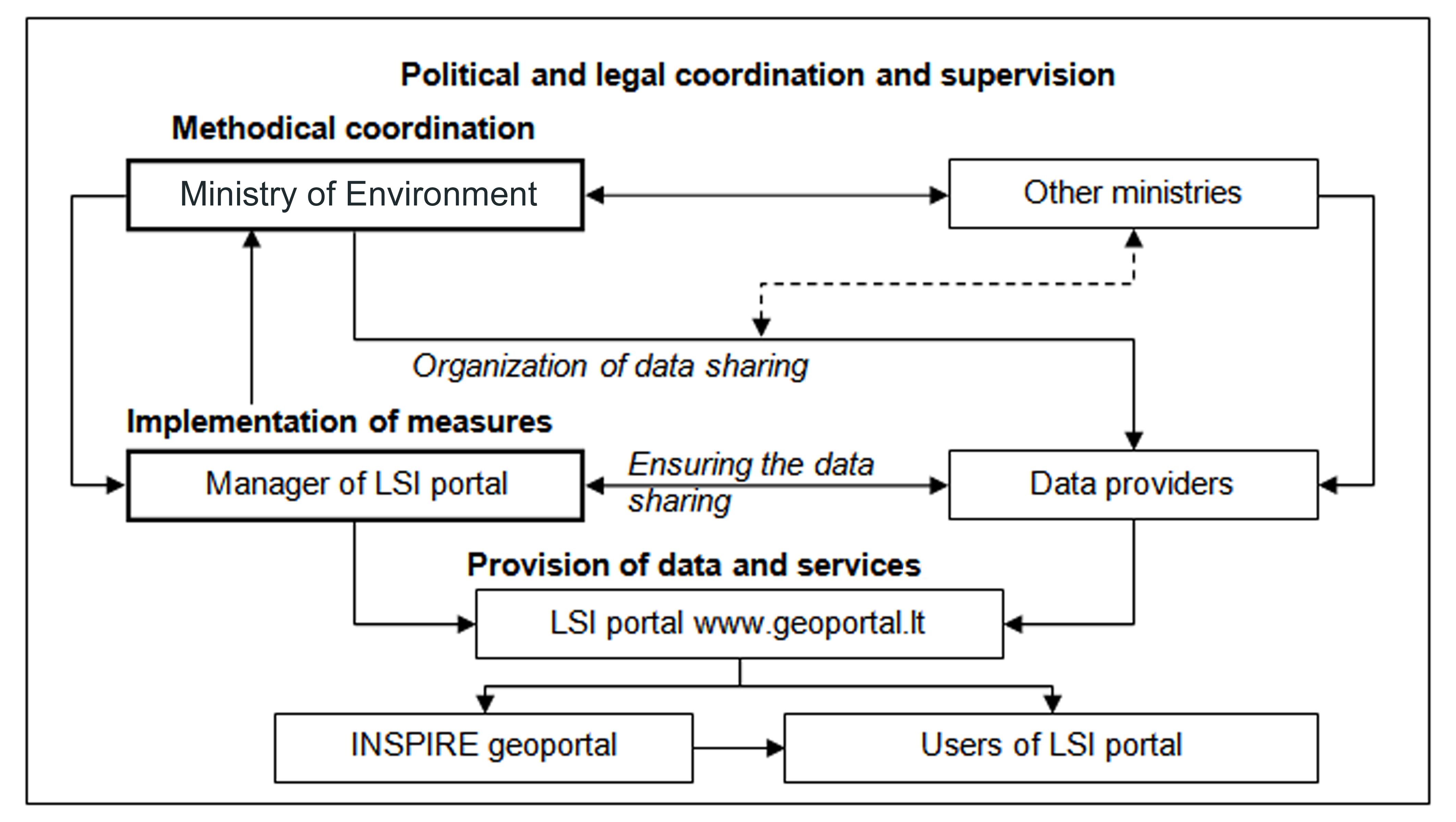
Since 03-01-2023 the Ministry of the Environment is the designated governmental authority, responsible for the implementation of the INSPIRE Directive in the Republic of Lithuania (Ministry of Agriculture co-ordinated INSPIRE activities by 03-01-2023.). Ministry of Environment is responsible for the development of SDI measures to ensure operational capacities of metadata, data sets, network services, sharing services for the themes referred in the Annexes of the Directive. It also maintains the link to the INSPIRE portal.
Ministry of Environment is responsible for:
- acting as a governmental representative in the INSPIRE Committee;
- monitoring the establishment and use of the spatial data infrastructure in Lithuania;
- submitting reports on the implementation of the Directive in Lithuania to European Commission.
The Law on Geodesy and Cartography of the Republic of Lithuania is the principal law transposing the Directive to national legal framework in the Republic of Lithuania. Detailed requirements for the implementation of the INSPIRE Directive are laid down in Government Decrees of the Republic of Lithuania, Orders of the Minister of the Environment and other subordinate legal acts.
The Resolution of Lithuanian Government of 13 October, 2010, No. 1460 and its amendments (the latest amendment of 5 February 2025, https://e-tar.lt/portal/lt/legalAct/92867760e90c11ef8bf78f8ccc0e0474) sets the list of the datasets corresponding to Annexes of the Directive, which shall be provided to users within Lithuanian spatial information infrastructure.
Lithuanian Spatial Information portal (LSI portal, www.geoportal.lt) is the main technological platform implementing the provisions of the Directive. It provides the single national access point to spatial data and services. It is the primary source of national spatial data and services to the INSPIRE geoportal.
The operating (technical) manager of the LSI portal is Public Enterprise “Construction Sector Development Agency” (hereinafter CSDA). CSDA is responsible for:
- management of the systems of the LSI portal and ensuring a continuous operation of the services;
- content administration of the LSI portal;
- collection, arrangement and management of metadata;
- development and maintenance of the LSI portal web services;
- management of data license agreements;
- monitoring of the provision of spatial data and services;
- support and consultation of LSI portal users and data providers;
- ensuring security of LSI portal information;
- provision of spatial data and services to the INSPIRE geoportal.
The data providers are the state and municipal authorities and other legal persons, responsible for creation and management of spatial datasets. Any data provider (state or commercial, NGOs or physical persons) can share their spatial data in the LSI portal free of charge if the data are considered being valuable for the society.
In accordance to the procedure and under the conditions laid down by the Law on Geodesy and Cartography and the LSI Portal Regulation, the manager of the LSI portal maintains data provision agreements with the LSI portal spatial data providers.
Provision of spatial data and services to the INSPIRE geoportal is also regulated by data provision agreements. Data providers are responsible for transformations of spatial data according to the INSPIRE data specifications. LSI portal manager is responsible for creating INSPIRE compliant metadata and network services of the datasets. LSI portal manager provides regular consultations on LSI portal benefits and organizes trainings on proper provision. Users of the services of the LSI portal are physical and legal persons who use the data of the LSI portal, spatial data sets and their metadata through the spatial data services and interactive e-services of the LSI portal.
Progress
Since 2022, two major reorganizations of the LSI portal operator took place. On January 3, 2023, a new state enterprise “Agricultural Data Center” (ADC) was established, merging three state enterprises, including the former operator of the LSI portal state enterprise “GIS-Centras”. After the fusion the responsibilities on maintenance of LSI portal were carried out by the Spatial Information Department within the ADC. In January 2024, the Spatial Information Department was moved and merged into another organization – public enterprise “Construction Sector Development Agency”, supervised by the Ministry of Environment.
The second restructuring has improved the situation, as the current enterprise is managed entirely by the Ministry of the Environment. However, with this restructuring, the overall strategic direction of improving the efficiency of the construction sector has been launched, which poses new challenges in terms of the need for spatial data.
The war in Ukraine, the global political situation and national security issues are driving the search for solutions to protect sensitive spatial data from hostile countries. Every effort is being made to strike a balance between maximum data openness and data protection.
The technological solution for provision of INSPIRE data is based on Geonetwork platform. Hale studio is used to analyse, transform and validate INSPIRE data sets. Various commercial software is used for partial data processing tasks.
Some separate datasets within one INSPIRE theme have been combined into one dataset. Although the total number of datasets was thus reduced, we believe that this approach is more efficient and more convenient for the users. Interactive services of the LSI portal have been improved and extended. The functionality, including usage by mobile devices, was improved.
Currently, the operator of the Lithuanian geoportal provides the necessary internal resources and competences for the implementation of INSPIRE in Lithuania. All INSPIRE network services are maintained and updated. Lithuania still stands out among other EU Member States in terms of the relative volume of dataset download services, which is 100%. There are still some uncertainties about priority datasets that have not been transformed according to the requirements of the INSPIRE data themes. While these datasets are undoubtedly valuable and must be provided, their provision worsens some formal country indicators. The European Commission has adopted a Commission Implementing Regulation (https://eur-lex.europa.eu/legal-content/LT/TXT/?uri=CELEX:32023R0138) implementing Article 14(1) of Directive (EU) 2019/1024 of the European Parliament and of the Council of 20 June 2019 on open data and the re-use of public sector information, which establishes a list of specific high-value datasets and the procedures for the preparation, publication and re-use of the high-value data contained in it. The Implementing Regulation entered into force on 9 February 2023. The spatial datasets submitted to the EU INSPIRE geoportal represent a significant part of the Lithuanian High Value Datasets (HVDs) that need to be opened. There is an ongoing debate on whether the data available in the EU INSPIRE geoportal can be considered open at European level, and on the relationship between the Lithuanian Open Data Portal and the Lithuanian Spatial Information Portal – where organisations should submit open spatial data to avoid duplication. There are also differences in the treatment of open, spatial and high-value data in different areas managed by different institutions. We draw attention to the need for an inter-institutional spatial data policy and the need for unified coordination of data sharing.
Functioning and coordination of the infrastructure
- In Lithuania, national spatial data infrastructure is centralised and accessible via national LSI portal: https://www.geoportal.lt/. The objective of the LSI portal is to facilitate a centralised access to spatial data sets, web services and their metadata. The LSI portal allows an integration of public sector spatial information (state and municipal organisations), data from state registers and information systems, and important spatial information from other sources (business, NGO, research and education etc.).
- There is a list of organizations and spatial data sets that these organizations must provide, regulated by the Resolution of Lithuanian Government of 13 October, 2010, No. 1460 (https://e-tar.lt/portal/lt/legalAct/92867760e90c11ef8bf78f8ccc0e0474). Other data providers may do so voluntarily. Provision of original spatial data is subject to spatial data provision agreements, maintained by the LSI operator. Some of the open data required for INSPIRE themes are not included in the data provision agreements. Their updating and transformation is the responsibility of the LSI portal operator. In January 2025, there were 56 spatial data providers of ca. 400 individual spatial data sets.
- The main public spatial data providers are national agencies such as Centre of Registers, Centre for Agricultural Data, Construction Sector Development Agency, Environmental Protection Agency, Department of Cultural Heritage, Lithuanian Geological Survey Service, Lithuanian Hydrometeorological Service, National Land Service, State Forest Survey Service, State Territorial Planning and Construction Inspectorate.
- There are 60 municipalities that have spatial information systems and some – local infrastructures at very different level of development. Spatial data of Lithuanian municipalities are provided in LSI portal as integral parts of national datasets or, in specific cases, individually by the municipalities.
- LSI portal operator provides all INSPIRE data to the INSPIRE geoportal. LSI portal operator offers several versions of basemaps, API’s for place name search, free consulting and ample technical support for the spatial data providers.
- Policy group for Cadastre and Spatial Data at the Ministry of Environment ensures inter-institutional coordination of activities related to the implementation of the INSPIRE Directive and secures the necessary legal framework.
- The network services of the LSI portal are publicly accessible at www.geoportal.lt: in Lithuanian and English user interfaces. Data and services for INSPIRE themes are accessible at https://www.inspire-geoportal.lt/geonetwork/srv/eng/catalog.search#/home. In addition, 80 priority data sets that are not in any data theme are available at https://inspire-geoportal.ec.europa.eu/srv/eng/catalog.search#/results?country=lt&view=priorityOverview&theme=none&iacs=none&legislation=none&envdomain=none&basedomain=0
Usage of the infrastructure for spatial information
- The major part of data and services at the LSI portal are provided free of charge under CC BY 4.0 open licence. Previous variety of specific agreements on data use has been replaced by General conditions for data use (https://www.geoportal.lt/geoportal/en/web/en/general-conditions-for-the-use-of-spatial-data) to which all users of geoportal.lt must agree.
- There are some datasets that can only be accessed by registered and authenticated users, and some datasets that are provided for non-commercial purposes only. But in general, since 2022 the conditions for accessing spatial data have become much simpler for users.
- In January 2025, the LSI portal has ca. 25,000 registered users, which are mainly GIS professionals in different areas. The most of spatial data services are accessible without registrations. Overall yearly number of spatial data requests is about 4 million. Of them, INSPIRE view services comprise ca. 0.5 million (INSPIRE download services aren’t monitored).
- More and more users are using the portal’s mobile app. There is a trend towards an increasing number of devices per user with the mobile app installed. In view of these statistics and the comments made by users, we recommend, as before, to consider the creation of an iOS version – in January 2025 – ca. 47,000 users with ca. 96,000 devices. Generally, almost 1% of Lithuanian population are LSI portal users.
- The usage of the Lithuanian Spatial Infrastructure had slowed down since 2018 and was 3 to 5 % yearly, depending on indicator, till 2022. At the end of 2022 total number of provided services reached 3,6 million and the number of registered users exceeded 22 000. As a result of the war in Ukraine in 2022 due the temporal restriction to spatial data referred to a potential threat to public security and national defense, the data use in LSI portal slowed down. The growth momentum was regained in 2023 and reached 7%. Explosive growth of 83% was observed in 2024 due to new ortophotographic maps published after some delay.
- About 40 % of users are from the non-governmental sector. Research and academic organisations comprise about 10% of registered users, business about 30% of registered users.
- The data and web services of the LSI portal have contributed to increasing the competence and knowledge of spatial data users. Users more often make decisions and solve business problems using spatial information, especially in spatial planning. Such tendencies have been observed in the LSI portal by the increased use of appliedweb services and more comprehensive nature of queries and user requests.
- The LSI platform allows Lithuanian public administration bodies to work more efficiently. Specific legislations in the INSPIRE themes related activities demand authorities in providing spatial data to the LSI portal and public services, help increasing quality of reports, increase and better visualised argumentation for decisions making or public consultation activities.
- Providers of spatial information services are more interested in utilizing the LSI webservices than creating own webservices. Lithuanian public administration bodies still lack competence and human resources to make best use of the infrastructure. Continuous training and user consultation on optimal use of LSI portal tools and operational capacities of spatial data is needed.
- The LSI data services are particularly important to municipal and state authorities which have limited resources, but shall perform public administration tasks applying spatial data (e.g., to check out the specific location and grant an authorisation for cutting down a tree or to measure a distance to river or lake). Spatial data, provided by the LSI portal facilitate in solving various analytical issues, contributing to improve workloads and adding an extra value in various information systems.
- An electronic survey of geoportal.lt users was carried out from 05-04-2023 to 15-04-2023. The average rating of the portal’s services is very high – 82.8 out of 100.
Data Sharing Arrangements
- Compared with the previous period, more open data has been introduced in the LSI portal and procedures to access some of the spatial data have been simplified.
- According to the law on Geodesy and Cartography state spatial datasets are licensed according to Creative Commons licensing templates, and a majority of such datasets are available to licensed users free of charge.
- Agreements on provision of data are reached by harmonising the regulations on information systems amongst the designated authorities. Most of data provision agreements are standardised, but there are also specific conditions in some agreements that depend on the nature of data services and on the policies of the data owner. Agreements typically specify the subject matter of the agreement, legal basis for the provision of data, obligations of the parties, data protection rules, etc.
- Data sharing between state and municipal authorities is governed by regulations on relevant information systems where external spatial data flows and their sources are specified.
- In accordance with the Law on Geodesy and Cartography, spatial data sets and services, required by institutions of the European Union, state authorities and municipalities to carry their public tasks or to arrange reports in accordance with European Union legislation relating to the environment, shall be provided free of charge. Providers of spatial data sets have the right to restrict access to spatial data sets via the LSI portal only if such exception is stipulated in laws. Community institutions and bodies may use web services of the LSI portal under the same procedure as they are used by legal and natural persons in Lithuania, by signing such agreements on the use of data as provided for a specific spatial data set provided through the webservice of the LSI portal. Conditions of the agreements on the use of data are available in Lithuanian and English.
- Relationships of the LSI portal with 56 data providers and about than 30 organisations that manage various state and business information systems are maintained.
Costs and Benefits
It is difficult to separate costs for general LSI development, LSI portal maintenance and development and specific INSPIRE Directive implementation costs. The costs incurred during the reference period are divided into two parts:
- One time project costs for the implementation of INSPIRE network services, metadata and spatial data sets in the LSI infrastructure.
- Annual maintenance costs for the LSI portal covering the following categories: – Hardware maintenance costs (around 30 % related to INSPIRE), – Software maintenance costs (around 25 % related to INSPIRE – reduced by introduction of open-source technology), – Maintenance work costs (around 30 % related to INSPIRE), – Monitoring and reporting costs (around 10 % related to INSPIRE).
LSI data providers (but not all) indicate relatively low annual costs (in average – about 60 000 EUR) occurred due to the obligation to follow the requirements of the Directive. The costs were accommodated in the annual state budget.
Total investment in the LSI between 2007 and 2024 was €15 million, of which €9 million was from EU Structural Funds. The estimated investment in INSPIRE components is €2.1 million.
As the costs of the implementation of the Directive are inseparable from the benefits provided by the LSI and the LSI portal, any claims regarding the possible development of the national spatial data infrastructure without the Directive would be speculative. The Directive had an undoubted influence on the spatial data strategy in Lithuania.
The following benefits are considered directly related to the implementation of the Directive:
- The Directive created a legal framework for pursuing interoperability and common use of spatial data. This simplifies arranging relevant agreements with spatial data providers and setting webservices.
- The Directive creates an obligation to provide metadata thus informing users about the existing spatial data sets. As a result of implementation of this requirement, the awareness of the authorities and the public to the existence of information resources collected by the state has increased manifold.
- INSPIRE promotes public provisions to open and monitor spatial data and their use. We shall confirm that, in the absence of the legal obligations, some data providers would not be interested in disclosing their data sets. The directive imposed better understand the user demands and adjust the development of state spatial data according to those demands.
Evidence of direct benefits observed in Lithuania:
- Adoption of the Directive led to focused policy development in the field of spatial information;
- Benefits observed in the field of environmental policy: obligation to improve the quality of existing data and provide modern spatial data services;
- The understanding among the authorities of the benefits of spatial information, integration of various data to spatial data (location based) and the possibilities of using them in decision-making has improved.
- Society is better informed and the demand for spatial data services have been increased;
- More projects are implemented, and spatial data products created. There is a growing number of initiatives related to a broader use of spatial data and innovative webservices.
Much greater economic and social benefits are generated at the national level as the overall outcome of the functioning of the infrastructure for spatial information. Aspects of the common benefits generated by the LSI are the same as have been indicated in the previous reports:
-
Economic benefits achieved as a result of the increased efficiency. These benefits are primarily quantified in work time costs; by multiplying these costs by an average salary of an employee from a relevant field, an expression of these benefits in financial terms may be obtained; however, it must be noted that work time saving does not in itself guarantee financial benefits, thus it cannot be classified as direct benefits. The assessment of the cost-benefit analysis of the implementation of the Directive during the reference period in each year of functioning of the Lithuanian Spatial Information Infrastructure identified savings of around 40.000 working days. Overall economic benefit in 2024 amounts to annual EUR 100 million.
- Indirect benefits achieved as a result of greater spatial data and existing LSI tools for decision-making. Where decision-makers are better informed, this leads to less problems and arguments, and the resulting financial and time costs are reduced. Examples of such benefits are as follows:
- Improved availability and transparency of spatial data sets resulted in a smaller number of territorial pre-litigation disputes and legal proceedings arising out of the incompatibility of spatial data sets;
- The land owners being able to view parcel data online, they are better informed, resulting in lower fines for abandoned land administration; the use (restitution) of land more effective resolution of issues;
- More effective registration of errors and a smaller number of related errors in spatial data sets;
- A number of reduced duplication of spatial data sets (it is unnecessary to keep copies available online) and no need for repeated efforts to collect similar data sets.
- Indirect benefits achieved as a result of increased use of spatial information to create various services and new spatial data sets. Examples of such benefits are as follows:
- Higher number of ongoing projects for the development of spatial information systems, greater demand for professionals, new jobs;
- New spatial data sets are created by using the main national spatial data sets, thereby conferring added value to the collected information, for example, maps displaying the distribution of criminal offences, tourist routes, objects of folklore and literature;
- Charter distributed data collection (crowdsourcing) by users create spatial data sets, for example, error or issue notifications, tourist information, etc.
- Indirect social benefits primarily linked to improved awareness and motivation at all levels:
- strengthened cooperation between different organisations by using the same spatial data as an instrument for interconnection;
- qualitatively new possibilities for using spatial information, increasing number of creators of spatial data and added-value services, especially among educational institutions; less investments in hardware and software and more investments in innovative products;
- better citizens’ awareness of the living and business environment, ability to use spatial analysis tools and more active participation in decision-making; better awareness of officials is linked to expected higher rates of “good” decisions (i.e. fully justified taking account of the more influential environmental factors) decisions.