HR - 2025: Country Fiche
Table of Contents
Introduction
The INSPIRE Directive sets the minimum conditions for interoperable sharing and exchange of spatial data across Europe as part of a larger European Interoperability Framework and the e-Government Action Plan that contributes to the Digital Single Market Agenda. Article 21 of INSPIRE Directive defines the basic principles for monitoring and reporting. More detailed implementing rules regarding INSPIRE monitoring and reporting have been adopted as Commission Implementing Decision (EU) 2019/1372 on the 19th August 2019. This Country Fiche highlights Croatia progress in the various areas of INSPIRE implementation. It includes information on Monitoring 2024 acquired in December 2024 and Member States update.
State of Play
A high-level view on the governance, use and impact of the INSPIRE Directive in Croatia. More detailed information is available on the INSPIRE knowledge base
Coordination
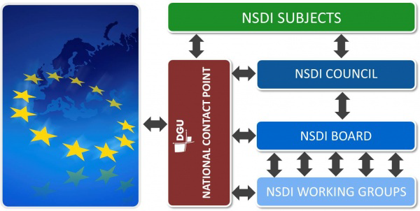
National Contact Point
- Name of Public Authority: State Geodetic Administration
- Postal Address: Gruška 20., 10000 Zagreb, Croatia
- Contact Email: info@dgu.hr; infonipp@dgu.hr
- Telephone Number: +385 (0)1 6165404
- Telefax Number: +385 (0)1 6165484
- National INSPIRE Website: https://www.nipp.hr/
- MIG Contacts:
- Contact Person: Ljerka Marić
- Email: ljerka.maric@dgu.hr
- Telephone Number: +38516166533
- Contact Person: Tomislav Ciceli
- Email: tomislav.ciceli@dgu.hr
- MIG T Contacts:
- Contact Person: Tomislav Ciceli
- Email: tomislav.ciceli@dgu.hr
Coordination Structure & Progress:
Coordination structure
The main governing body of NSDI in the Republic of Croatia is the NSDI Council. It is a body that implements the NSDI within the Republic of Croatia and coordinates the activities of NSDI subjects within the scope and with rights and obligations determined by the Law on National Spatial data infrastructure (OG 56/13, 52/18, 50/20).
Governmental authorities at the level of ministries mainly join this NSDI Council, but also relevant (branch) associations as well as National Contact Point (NCP).
The Act Amending the National Spatial Data Infrastructure Act (OG 50/20) of 2 May 2020 introduced changes in the composition of the NSDI Council in order to achieve its more efficient work. Therefore it was proposed that the President of the Council is a representative of the National Contact Point and that a new member from the State Hydrometeorological Institute is included in the new composition. Additionaly, it governs that exchange and sharing of data at the national level is regulated by a protocol, whereas the sharing of spatial data between NSDI entities and European Commission bodies is regulated by an agreement.
At the managerial level is the NSDI Board, a permanent body for NSDI implementation. The NSDI Board is appointed by the NSDI Council and consists of three representatives from the NSDI Council, three from the NCP, and the heads of NSDI working groups.
At the operational level, till February 2021, three NSDI working groups were established for the purpose of elaborating certain tasks and obligations within the scope of the NSDI implementation:
- Workgroup for NSDI technical standards
- Workgroup for NSDI capacity building
- Workgroup for NSDI spatial data.
In 2024, new Working group for spatial plans was established with the aim of making recommendations for registering spatial planning documentation in Croatian NSDI.
The NCP is responsible for leading the implementation of the NSDI and the coordination of the activities of the NSDI subjects within the scope and with rights and obligations determined by the Law.
Progress
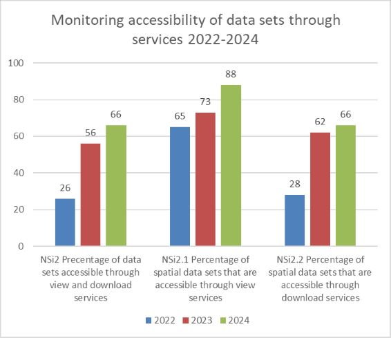
As the Republic of Croatia became an official EU member on 1st July 2013, it was not obliged to submit the INSPIRE monitoring and reporting forms before that date. The first Reporting was submitted in 2016 and progress has been made since then in many areas. The number of identified spatial datasets and documentation of data through NSDI geoportal and Metadata Catalogue has grown as well as accessibility of data through network services and conformity of spatial data sets and services.
In 2024, the fourteenth conference dedicated to spatial data infrastructures, Days of NSDI 2024 was organized by NCP as well as two advanced workshops on the topic of raising the quality of metadata and data harmonization for NSDI subjects. In order to help local and regional self-government units, a series of individual meetings were held in 2024 in order to speed up and improve the process of metadata description of spatial data sources in the NSDI Metadata Catalog.
Functioning and coordination of the infrastructure
-
In 2021 the State Geodetic Administration prepared a report on the implementation of measures and activities from the National Spatial Data Infrastructure Strategy 2020 and the National Spatial Data Infrastructure Strategic Plan for the period 2017-2020, which was firstly adopted by NSDI Council and after that adopted by the Croatian Government in the beginning of 2022.
-
Data providers themselves choose software and hardware for the publication of spatial data and services, with the fact that from 2020 they have the option of publishing harmonized data from the platform https://transformiraj.nipp.hr/ which is run by the State Geodetic Administration, and is based on the Hale connect solution.
-
The Law on National Spatial Data Infrastructure (OG 56/13) has undergone two amendments to enhance its alignment with EU directives and improve its implementation. The first amendment, in May 2018, ensured full compliance with the INSPIRE Directive. The second amendment, adopted by the Croatian Parliament in April 2020 (OG 50/20), aligned the law with Regulation (EU) 2019/1010 of the European Parliament and Council. In addition, the composition of the Council of the National Spatial Data Infrastructure is changed in order to achieve more efficient work of the Council, as well as the competences of the National Contact Point regarding reporting by Member States to the European Commission. Furthermore, the Act on Amendments to the National Spatial Data Infrastructure Act (OG 50/20), with the aim of harmonization with the Law on State Information Infrastructure (Official Gazette, No. 94/14), proposes that the exchange and sharing of data at the national level is regulated by a protocol, while the sharing of spatial data between NSDI entities and European Commission bodies is regulated by an agreement. The Act Amending the National Spatial Data Infrastructure Act (OG 50/20) entered into force on 2 May 2020.
-
In September 2017 the government of the Republic of Croatia adopted the Decision on the adoption of the National Spatial Data Infrastructure Strategy 2020 and the Strategic Plan of the National Spatial Data Infrastructure for the period 2017-2020 (OG 96/17). The adoption of the NSDI Strategy helps all stakeholders, primarily NSDI subjects, to achieve compliance with the INSPIRE Directive. It further emphasizes the centralized access to spatial data of the public bodies through the NSDI geoportal, which results in greater efficiency of state administration in areas directly or indirectly linked to spatial data. Fulfillment of the strategic goals increases the number of spatial data present, primarily at the regional and local level, where the largest number of new NSDI subjects are expected.
-
The Law on National Spatial Data Infrastructure (OG 56/13) was adopted by the Croatian Parliament in May 2013.
Usage of the infrastructure for spatial information
-
By December 2024, more than 20,000 users had accessed the NSDI Geoportal and GeoHrvatska spatial data viewer that enables users to get to know and explore the surrounding area using official spatial data through NSDI.
-
In 2024, NSDI Metadata Specification has undergone changes to comply with new version of Technical Guidance for the implementation of INSPIRE dataset and service metadata based on ISO/TS 19139:2007 from January 2024. Those changes have been implemented to the national catalogue on the national Geoportal.
-
Mobile application GeoHrvatska was also developed in 2022 by the State Geodetic Administration with the aim of promoting and simplification of the use of spatial data by citizens through every day scenarios such as planning of recreation, trips, exploring land, finding best locations and so on.
-
Quantitative information about the use of the spatial datasets exists only for those datasets for which are developed network services.The most used network services are State Geodetic Administration’s Digital orthophoto, Topographic Map 1: 25 000 and Cadastral parcels and Cadastral municipalities as well as Addresses and Administrative units.
-
NCP has encouraged NSDI subjects to implement their own metadata catalogues based on NSDI Metadata Specification and now NSDI geoportal is harvesting two such catalogues from the Ministry of Environmental Protection and Green Transition, Croatian Bureau of Statistics and Ministry of Agriculture, Forest and Fishery.
-
The use of the infrastructure for spatial information has grown in previous years which can be seen from larger numbers of access to NSDI geoportal for more than 30%.
-
NSDI is also used in education in the Republic of Croatia. Research made on several high schools and universities in Croatia showed that NSDI is used for educational purposes in at least 3 faculties and 1 high school.
-
State Geodetic Administration, from 2019 to 2021 was implementing the project “Strengthening Capacities for the Establishment of the National Spatial Data Infrastructure”. The project was co-financed by the European Social Fund from the Priority Axis 4, Operational Program Effective Human Resources 2014-2020, Investment Priority 11.i., Specific goal 11.i.1. The main goal of the project was to strengthen the existing NSDI capacities at the National Contact Point and local promoters, as well as to raise NSDI knowledge at the local, regional and national levels thus resulting in the increase of the number of NSDI subjects. In scope of project, during 2021, 11 workshops were organised primary for representatives from local government.
-
State Geodetic Administration, from 2019 to 2021, was implementing the project „Increasing the availability of NSDI spatial data through e-services“ funded from the European Regional Development Fund, aiming to increase availability and interoperability of spatial datasets in Croatia. In scope of project, the module “Example of good practice for the use of NSDI spatial data” was developed and it is publically available as a part of the NSDI Geoportal browser. In 2020, new version of NSDI Metadata Specification was implemented to the national catalogue on the national Geoportal.
-
At the end of 2019, a new version of the NSDI Metadata Specification, that is fully compliant with the new INSPIRE Implementing rules for metadata “Technical Guidance for the implementation of INSPIRE dataset and service metadata based on ISO/TS 19139:2007 “, was adopted. In the Specification the emphasis is on implementation rules of xml coding of metadata elements in accordance with norm ISO / TS 19139: 2007 taken as a reference, international standard for metadata coding. New Specification, in which metadata elements are divided into compliance classes, provide better support in automatic metadata validation.
-
Communication Plan of National Spatial Data Infrastructure was written in December 2018 and its goal is to define the best methods for communication with different stakeholders including the general public and further raise the awareness on benefits of spatial data infrastructure.
Data Sharing Arrangements
-
The goal of Croatian SDI is to facilitate data sharing among public authorities and enable its re-use for different purposes. Since 2020, when the Act on Amendments to the National Spatial Data Infrastructure Act (OG 50/20) came into force, the exchange and sharing of data at the national level has been regulated only by a technical document –protocol, what means that formal agreements are no longer required.
-
In 2022, Law on State Survey and Real Estate Cadastre was amended to stipulate that the use of network services is free of charge for all data under the State Geodetic Administrations responsibility.
-
In 2023 SGA has adopted the Ordinance on determining the actual costs of issuing and conditions of using data (OG 56/2023) which published a list of SGA data for reuse, including high-value datasets that are available through services and an open license.
-
Collaboration between institutions has fostered co-financing of significant data acquisition projects, leading to both data sharing and cost reduction. Examples include:
-
The creation of the Digital Orthophoto, co-financed by the SGA and the Agency for Payments in Agriculture, Fisheries, and Rural Development, and the Multisensor Aerial Survey of the Republic of Croatia, implemented through joint efforts by multiple institutions.
-
The Agency for Payments in Agriculture, Fisheries, and Rural Development has established agreements with various institutions, such as the Croatian Bureau of Statistics, to improve the quality and efficiency of statistical data related to agriculture and rural development.
-
-
Data exchange and sharing are common among most Croatian public authorities and European Community institutions and bodies. For example, the Meteorological and Hydrological Service exchange daily data in the context of the European Flood Awareness System and World meteorological services. State Geodetic Administration has provided data for European Environment Agency and Eurostat.
-
Many spatial data providers in Croatia, including the State Geodetic Administration, make their data available free of charge under an open license of the Republic of Croatia. These datasets, such as cadastral data, topographic maps, and spatial plans, support transparency and innovation by enabling individuals, businesses, and institutions to freely use and repurpose spatial data for various purposes.
Costs and Benefits
Benefits:
Although no quantitative values of the INSPIRE implementation benefits can be given, there are many positive feedbacks to INSPIRE implementation and using National Spatial Data Infrastructure:
- Using NSDI has led to cost reduction as data can be re-used in other institutions and duplication of data acquisition can be avoided.
- Stakeholders use the Metadata Catalogue and NSDI geoportal for their needs regarding spatial data since all necessary information regarding the data can be found there (e.g. terms of use, resolution, data coverage).
- NSDI subjects when providing INSPIRE services for their spatial datasets decide to make them free of charge, thus allowing private sector to use these data to create new products and expand the spatial data market. In general, the NSDI significantly contributes to enhancing knowledge on spatial data management issues. By promoting best practices and fostering collaboration among stakeholders, it plays a vital role in improving the accessibility and use of spatial data.
Costs:
According to the report on the implementation of measures and activities from the National Spatial Data Infrastructure Strategy 2020 and the National Spatial Data Infrastructure Strategic Plan for the period 2017-2020 overall costs for was 10 814 566 Euros divided in 7. Strategic goals. Implementation costs for each of the strategic goal were:
-
Strategic goal no. 1: NSDI is known and the benefits it brings The cost in this strategic goal during the period 2017 - 2020 amounts to 51 188 euros and mainly refers to participation in workshops and conferences and implementation of spatial data portals of some NSDI subjects.
-
Strategic goal no. 2: Spatial data and services are available and meet the needs of users The cost in this strategic goal during the period 2017 - 2020 amounts to 4 614 244 euros and it refers to the development of network services (view and download).
-
Strategic goal no. 3: Terms and fees for the use of spatial data are easy to understand The cost in this strategic goal during the period 2017 - 2020 amounts to 12 088 euros and it refers to development of standard licenses (open and special) for spatial data and workshop on licensing of data.
-
Strategic goal no. 5: There are sufficient operational options available for the effective and efficient use of the NSDI The cost in this strategic goal during the period 2017 - 2020 amounts to 5 766 823 euros and it refers to all the projects aiming to implementation and development of NSDI in Croatia, co-financed from EU funds, especially of those in which information systems and INSPIRE network services have been developed.
-
Strategic goal no. 6: NSDI supports other important policies and programs at the national and international level This strategic goal refers to compliance to INSPIRE of datasets, network services and metadata and the cost in this strategic goal during the period 2017 - 2020 amounts to 166 750 euros.
-
Strategic goal no. 7: NSDI stakeholders (NSDI entities and beneficiaries) cooperate through partnerships and other types of agreements
This strategic goal refers to concluding cooperation agreements and inclusion of NSDI subjects and their metadata in the Catalog of Metadata on the NSDI Geoportal and the cost during the period 2017 - 2020 amounts to 203 473 euros.
The costs of developing NSDI are distributed across institutions that make the data available and the costs of NCP, so that a more recent consolidated cost analysis does not exist.