ES - 2025: Country Fiche
Table of Contents
Introduction
The INSPIRE Directive sets the minimum conditions for interoperable sharing and exchange of spatial data across Europe as part of a larger European Interoperability Framework and the e-Government Action Plan that contributes to the Digital Single Market Agenda. Article 21 of INSPIRE Directive defines the basic principles for monitoring and reporting. More detailed implementing rules regarding INSPIRE monitoring and reporting have been adopted as Commission Implementing Decision (EU) 2019/1372 on the 19th August 2019
This country fiche highlights the progress in the various areas of INSPIRE implementation. It includes information on monitoring 2024 acquired in December 2024 and Member States update.
State of Play
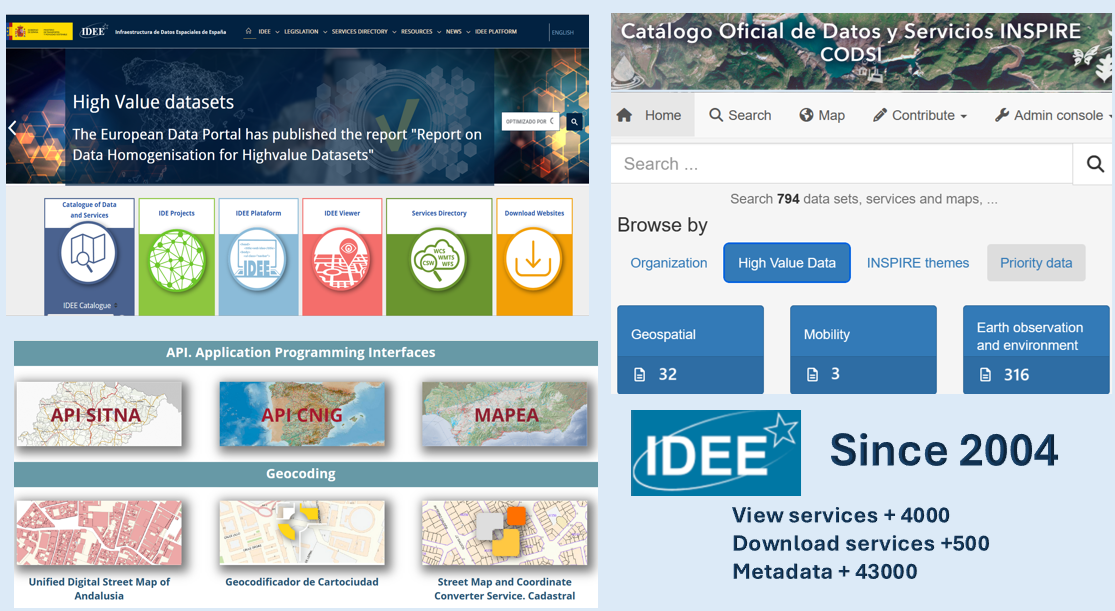
Spanish SDI (Infraestructura de datos Espaciales de España, IDEE)

Spain transposed INSPIRE Directive into national law since 2010, called LISIGE “Law about Infrastructures and Services about Geographic information in Spain”, and has been implemented and maintainted the national INSPIRE nodes and regional INSPIRE nodes since then.
Spanish SDI geoportal is the access point national and regional SDI have two catalogues, tools and publishes their information thought view and download services.
The spatial data is published in the above catalogs and is classified as follows:
- Annex I, II and III datasets have been published and most of them are harmonized according to INSPIRE.
- Priority datasets referring to environmental regulations have been identified and published.
- High value datasets defined in Regulation (EU) 2023/138 classified as geospatial, Earth observation and environment and mobility.
All of them are published through view and download services.
Spanish SDI paltform is meeting point for developers in the geospatial community, where different initiatives are brought together and their reuse is made easier:
- Citizen map: Collaborative project to create a national vector tile service with all official spatial data at national, regional and local level. the technology used is the vector tiles service and the licence is CC BY 4.0.
- Application Programming Interfaces (viewer):
- API SITNA of Navarre Government
- API CNIG of National Centre for Geographic Information.
- MAPEA of Regional Government of Andalusia
- Municipal Territorial Information System (SITMUN) of Diputació de Barcelona
- Geocoding:
- Unified Digital Street Map of Andalusia of Regional Government of Andalusia
- Cartociudad geocoder of National Centre for Geographic Information.
- Street Map and Coordinate Converter Service. Cadastral
The SDI of Spain is made up of the following SDI nodes at the national and regional levels (see SDI local nodes here.)
| National SDI nodes | |
|---|---|
| Ministry | Organization |
| National Cartographic System (SCN) | Coordinated production and publication of data through the National Cartographic Plan. SCN publishes the following datasets for the following INSPIRE themes: OI. TN, HY, GN, AU, CP, BU, AD, EL, LU, LC… involving national and regional bodies responsible for the data. Some collaborative projects: Citizen Map, Geo localisation of postal addresses and toponymy, Unified Cartographic Base… |
| Ministry of Finance | Main responsible for the following INSPIRE themes: AD, BU, CP |
| Directorate General for Cadastre | |
| Ministry of Transport, Mobility and Urban Agenda | Responsible for the following INSPIRE themes: TN, HY, GN, AU, LC, LU, EL, OI, NZ, etc |
| Administrator of Railway Infrastructures (ADIF) | |
| Government agency Puertos del Estado | |
| National Geographic Institute (IGN) | |
| Trans-European Transport Network (TEN-T) of Spain (HERMES proyect) | |
| Directorate General for Architecture, Housing and Land (Urban Information System) | |
| Spanish National Research Council (CSIC) | |
| Ministry of Economic Affairs and Digital Transition | Responsible for the following INSPIRE themes: SU, PD, etc. |
| National Statistics Institute | |
| Ministry of Defense | Responsible for the following INSPIRE themes: AU, US, etc. |
| Marine Hydrographic Institute (IHM) | |
| Ministry of Science and Innovation | Main responsible for the following INSPIRE themes: GE, SO, OF,SR, etc. |
| Geological and Mining Institute of Spain | |
| Oceanographic Spanish Institute SDI | |
| Ministry of Agriculture, Fisheries and Food (MAPA) | Main responsible for the following INSPIRE themes: AF, PF, AM, EF, etc. |
| Spanish Agrarian Guarantee Fund (FEGA) | |
| Ministry for the Ecological Transition and the Demographic Challenge (MITECO) | Main responsible for the following INSPIRE themes: SD, HY, HB, EF, MF, AC, PS, ER, etc. |
| Nature Database | |
| Geoportal petrol stations and recharging points | |
| Mining Cadastre | |
| State Meteorological Agency (AEMET) | |
| Hydrographic Confederations |
SDIs at regional level are regulated by a law or decree that establishes their functions to publish geographic information. For example, in 2022, Aragon government published the Law 3/2022, of 6 October, on Geographic Information in Aragon (LIGA) with the aim of establishing a legal regime for the geographical information and cartographic activity of Aragon. LIGA defines the Knowledge Infrastructure of Aragon (ICEARAGON).
| Regional SDI nodes | |
|---|---|
| Andalusia | SDI of the Andalusian Regional Government. (IDEAndalucia) |
| Aragon | Spatial Knowledge Infrastructure of Aragon. (ICEARAGON) |
| Balearic Islands | SDI of the Balearic Islands Government. (IDEIB) |
| Basque Country | SDI Basque Country. (geoEuskadi) |
| - Provincial Council of Gipuzkoa | SDI Gipuzkoa. (SDI Gipuzkoa) |
| - Provincial Council of Araba | SDI Araba. (GeoAraba) |
| - Provincial Council of Bizkaia | SDI Bizkaia. (GeoBizkaia) |
| Canary | SDI the Canary Islands Government. (IDECanarias) |
| Cantabria | SDI of Cantabria. (IDE Cantabria) |
| Castile and Leon | SDI of the Castile-Leon Regional Government. (IDEECyL) |
| Castile–La Mancha | SDI of the Castilla la Mancha Regional Government. (IDE-CLM) |
| Catalonia | SDI of Catalonia. (IDEC) |
| Extremadura | SDI of the Extremadura Regional Government. (IDEextremadura) |
| Galicia | SDI of the Regional Government of Galicia. (IDEG) |
| La Rioja | SDI of the Government of La Rioja. (IDERioja) |
| Madrid | SDI of the Community of Madrid. (IDEM) |
| Murcia | SDI of the Region of Murcia. (IDERM) |
| Principality of Asturias | SDI of Asturias from the Principality of Asturias Government. (SITPA-IDEAS) |
| Regional Community of Navarra | SDI of the Government of Navarre. (IDENA) |
| Valencian Community | SDI of Valencia. (IDEV) |
Coordination
National Contact Point
- Name of Public Authority: National Center of Geographic Information (National Geographic Institute)
- Postal Address: C/ General Ibáñez de Íbero 3, 28003 Madrid - España
- Contact Email: emilio.lopez@cnig.es
- Telephone Number: 034915979646
- Telefax Number: 034915979764
- National INSPIRE Website: [Spanish SDI (Infraestructura de datos Espaciales de España, IDEE)[(https://www.idee.es/)
- INSPIRE Maintenance and Implementation Group (MIG) Contacts:
- Contact Person: Emilio López Romero
- Email: Emilio.lopez@cnig.es
- Telephone Number: 034915979646
- Contact Person: Alberto Campos García
- Email: acampos@miteco.es
- MIG permanent technical sub-group (MIG-T) Contacts:
- Contact Person: Paloma Abad Power
- Email: paloma.abad@cnig.es
- Telephone Number: 034915979660
- Contact Person:
- Email:
Coordination Structure & Progress:
Coordination structure
Geographic High Council is the director body of the National Cartographic System (SCN), having consultation and planning role for the official geographic information and cartography. Geographic High Council is the National Contact Point for INSPIRE and the coordination and direction for the Spanish SDI.
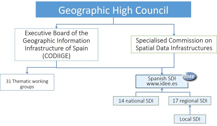
Geographic High Council created the Executive Board of the Geographic Information Infrastructure of Spain (CODIIGE) for managing and controlling IDEE. It takes responsibility for directing Spain’s SDI, and immediately began to define the Technical WGs with the objective of analysing the application of the implementing rules of INSPIRE by the Spanish Public Administrations and helping their bodies and Organizations to achieve compliance. Furthermore, it is the body responsible for coordination and management of the SDI of Spain, owing to which it is responsible for its constitution and maintenance, being responsible for:
- Proposing to the competent Authorities the actions to be performed by the Administrations or Organizations of the public sector for the establishment of the IDEE.
- Guaranteeing its accessibility and interoperability.
- Integrating the contributions of other producers or suppliers.
The CODIIGE deal with interinstitutional coordination the organization of Spanish SDI (IDEE) is based on 14 national and 17 regional nodes; each regional node establishes the necessary coordination with the local administration and other agents.
Depending on CODIIGE:
- There are some Thematic Working Groups (GTT), (one per INSPIRE Theme although some themes are grouped) with representation of all institutions with responsibility for data and/ or services under scope of INSPIRE. These Thematic Working Groups (GTT) have translated INSPIRE Technical Guidelines (Data Specifications) and have adapted to the case of Spain. These technical documents are available here.
- Identification of high-value datasets: geospatial, Earth observation and environment and movility.
- Identification of priority data through environment ministries: The Ministry of Agriculture, Fisheries and Food (MAPA) and the Ministry for Ecological Transition and the Demographic Challenge (MITECO).
- Furthermore, there are four transversal Working Groups (Metadata and catalogue; Network services; Monitoring and reporting; Data and services policy).
- Finally, there is a Working Group for the NSDI (GTIDEE) with representatives from public and private sector and academia. GTIDEE meets 2 times a year to discuss different aspects of the standars, Technical Guidance, open data and new technologies for the implementation of INSPIRE, Iberian Conference SDI and to coordinate the experts work on INSPIRE.
- Responsible for Spanish SDI Geoportal and their catalogues.
The National Cartographic System, defined in Royal Decree 1545/2007 and promoted by Law 14/2010, which establishes the coordination of data production via the National Cartographic Plan and the sharing of data between the Autonomous Communities that sign the generic agreement and the General State Administration.
- The data production are orthoimagery, hidrography, transport networks, land use and cover, elevation (DTM, DSM), etc.
- The National Cartographic System is made up of the following national and regional bodies, see here.
- On the following web page, you can consult the dates of the agreements of each of the autonomous organisations. see here.
Ministry of Agriculture, Fisheries and Food (MAPA) is responsible for the implementation of the government’s policy on agricultural, livestock and fisheries resources, agri-food industry and food and charged withtasks within the framework of the agricultural and fisheries community policy. Depending on MAPA there is:
Ministry for Ecological Transition and the Demographic Challenge (MITECO) is responsible for developing the government policy on fight against climate change, prevention of pollution, protecting the natural heritage, biodiversity, forests, sea, water and energy for a more ecological and productive social model. Depending on MITECO there are:
- Geoportal petrol stations and recharging points enables geospatial queries of fuel prices at petrol stations and electric recharging points.
- The Petrol Stations Geoportal is based on the information submitted on the basis of Order ITC/2308/2007, of 25 July, which determines the form of submission of information to the Ministry of Industry, Tourism and Trade on the supply activities of petroleum products, which is the development of Art. 5 of Royal Decree Law 6/2000 of 23 June, on urgent measures to intensify competition in goods and services markets.
- The electric recharging points is based on Order TED/445/2023, of 28 April, which regulates the information to be sent by energy recharging service providers to the MITECO, the Autonomous Communities and the Cities of Ceuta and Melilla, which is the development of article 48 of Law 24/2013, of 26 December, on the Electricity Sector.
- Recharging points can only be downloaded directly from the control access RIPREE website.
- Hydrocarbon Technical Archive: This archive is regulated in article 12 of Law 34/1998, of 7 October, on the hydrocarbons sector and in section 2.3 of article 11 of Royal Decree 2362/1976, of 30 July, approving the Regulations for the application of the Law on hydrocarbon research and exploitation of 27 June 1974, applicable in accordance with the Second Transitional Provision of Law 34/1998, of 7 October. The infrastructure associated with the archive also allows compliance with the provisions of Article 3 of Directive 94/22/EC of the European Parliament and of the Council of 30 May 1994.
- Mining Cadastre: The Mining Register is a permanently updated public archive of all existing mining rights in the national territory, territorial sea and continental shelf, with their corresponding map. The competence over mining rights lies with the Autonomous Communities, which manage the data in their respective mining cadastres.
- Integrated Information System of the Spanish Natural Heritage and Biodiversity Inventory (IEPNB)
- Nature Database
- State Meteorological Agency (AEMET)
Progress
High-Value Datasets (HVD)
The CODIIGE has carried out a preliminary study of High-Value Datasets (HVD) to be made available for re-use according to Commission Implementing Regulation (EU) 2023/138 of laying down a list of specific high-value datasets and the arrangements for their publication and re-use.
All datasets (100 %) are available for re-use under the conditions of the Creative Commons BY 4.0 licence, or any equivalent or less restrictive open licence allowing for unrestricted re-use and their metadata elements set out in the Annex to Regulation (EC) Nº 1205/2008.
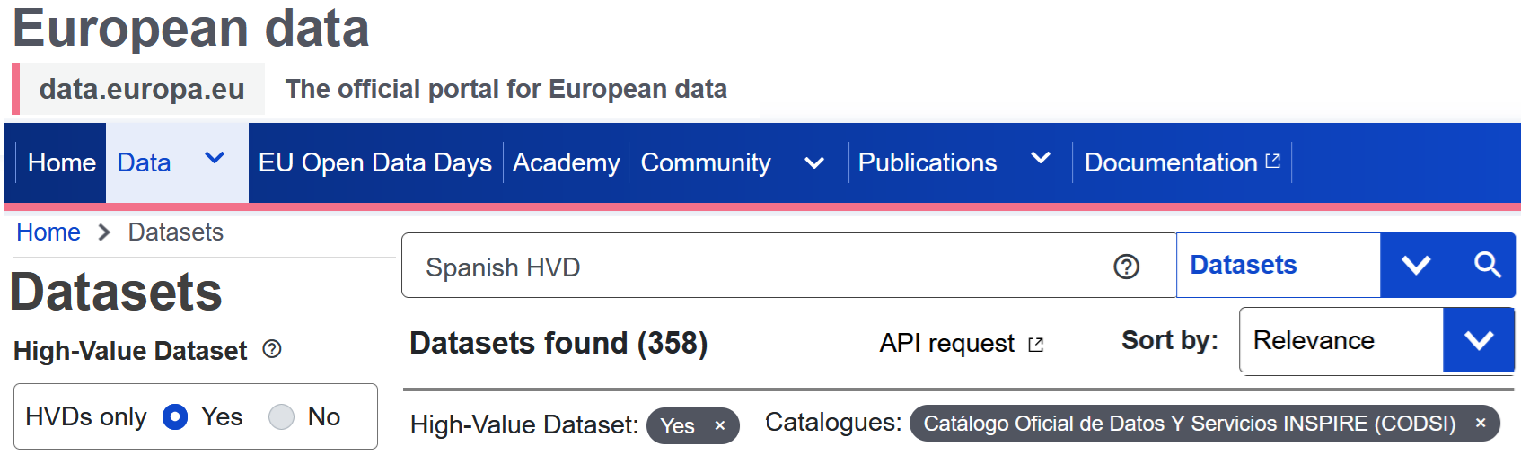
Those HVDs with national scope are accessible through their metadata in the Official Catalogue of Inspire Data and Services (CODSI).
| HVDs accessible in the CODSI catalogue | 2022 (HVD) | 2023 (HVD) | 2024 (HVD) |
|---|---|---|---|
| Geospatial | 29 | 32: 5 of AU, 7 of GN, 7 of AD, 6 of BU, 5 of CP, 2 of GSAA, LPIS | 32: 6 of AU, 5 of GN, 6 of AD, 6 of BU, 5 of CP, 3 of GSAA, LPIS |
| Earth Observation | 30 | 40 | 47 |
| Enviroment | 154 | 213 | 269 |
| Mobility | 3 | 3 of TN | 3 of TN |
358 Spanish HVD’s are published in CODSI, geoportal INSPIRE and European Data Portal in 2024.
Spain’s recovery and resilience plan Procurement for the modernisation of the Spatial Data Infrastructure for Spain (IDEE) through the Recovery, Transformation and Resilience Plan with an estimated budget of 11 052 000 € for the next 4 years (2021-2024). The contracts cover the following topics:
- Technological platform on the cloud.
- Adaptation of the IDEE to the new technological specifications such as the implementation and configuration of new network services compliant with INSPIRE Directive based on the API-OGC and development of client applications for their exploitation. (Examples of Spanish SDI OGC API here)
- Postal address service web management system: Working on the creation of national geocoder service to publish official addresses that will be the result of the harmonization and integration of official addresses the main suppliers of information about addresses at national, regional and local government organizations. In this project involves Directorate General for Cadastre, Basque Government, Government of Navarre and another regions like Valencia, Madrid, Andalucía… All of them are supported with the Postal Codes provided by the Post Office Group, names of streets of National Statistics Institute together with the official settlements of National Geographic Institute (IGN).
- Development of a national vector tile service: Creation of official base map multiscale, Citizen Map, from official sources national, regional and local sources. Its technology is based on vector tile services.
- Maintenance of national catalogues, validation of metadata and publication on the open data portal.
Strengthening the work carried out between the D.G. Cadastre and the Land Registry. The Spanish Law 13/2015 implements an effective coordination of transactions executed by Cadastre and the Property Rights Registry. These institutions are two separate organizations with differentiated mandates and competences, both working in the domain of land administration. The Cadastre, registries and notaries have worked together to design a technologically advanced model of institutional interaction for this coordination purpose based in the INSPIRE GML of the Cadastral Parcel and the position of the Building.
Navarra Territorial Information System (SITNA) had a Strategic Plan 2020-2023 And the new Strategic is Plan 2024-2028) where manages the official geographic information of the Government of Navarre, including compliance with INSPIRE and LISIGE requirements in terms of metadata, data and services.
Geospatially Enabled Ecosystem for Europe (GeoE3): National Cartographic System (SCN) of Spain co-operated with Estonia, Netherlands, Norway, Finalnd and OGC in the project co-financed by the Connecting Europe Facility of the European Union, GeoE3 project, since 2020 until 2024, providing a connection between existing and emerging national, regional and cross-border digital services. It provided a dynamic integration of high-value data sets and services (e.g. meteorological or statistical data) with geospatial features from existing national geospatial data platforms (e.g. building data or road network data).
The products of the National Cartographic System, SDI Catalonia and SDI Navarre are published through the OGC APIs in GeoJSON format. (see OGC APIs here)
Spanish Agrarian Guarantee Fund (FEGA) participates in DG AGRI process for IACS data sharing under INSPIRE
Emergency Registry Portal (PRE) of the Land Registry Office (CORPME) provides access to the land registers that enable the land registry properties to be located on the territory.
Conferences, meetings and workshops in 2024
- XIV Iberian Conference on Spatial Data Infrastructures 2024 was held in Vitoria (Basque Country) from 13 to 15 november under the slogan “The value of geospatial data” with a participation of 300 attendees mainly from Spain, Portugal and Andorra. There were 96 papers and 9 workshops, distributed in 24 sessions, in addition to the two round tables and the invited lectures.
- Free GIS conferences 2024 is an initiative of the SIGTE, a conference dedicated to the free software in the field of the Geographical Information Technologies. This event takes place at the University of Girona, since 2007.
- Holding of two Working Group for the NSDI (GTIDEE) meetings a year where MIG and MIG-T activities and other topics such as OGC APIs or company activities are disseminated (the number of attendees per meeting is around 140).
- Meetings of thematic groups such as the Biodiversity Bank.
Training:
- On line courses on Spatial Insfrascture Data since 2005 to the general public. One or two courses are given each year. One or two courses are given each year and since 2005 more than 3.000 students have been trained.
- Specific on line courses on OGC services, metadata, open data, etc. for public administration.
- Translation into Spanish and dissemination of the on line course on OGC API. The course is called Location Innovation Academy and has been developed within the GeoE3 project.
Functioning and coordination of the infrastructure
Functioning
- To facilitate data and service sharing and use has been developed:
- Spanish SDI Geoportal (IDEE) provides access to around 46 catalogues from national, regional and local nodes.
- Official Catalogue of Inspire Data and Services (CODSI) provides access INSPIRE data sets and network services. This catalogue is connected via harvesting or file interchange with the catalogues of national and regional SDI nodes, is the base for the monitoring process and for feeding the INSPIRE Geoportal. All INSPIRE compliant services available in Spain are available in European INSPIRE Geoportal.
- Spanish Registry based on Re3gistry.
- Much more OGC services are available but not all are INSPIRE compliant services and SDI Navarre, SDI Catalonia and National Cartographic System services publish their spatial data via OGC APIs
- The list of key spatial data sets required for other environmental policies is already identified.
-
Big effort on training, seminars, events at regional and local levels; twitter @IDEESpain with 3.491 followers, electronic monthly bulletin “SobreIDEs” and Spanish SDI Blog “Blog IDEE” with an average of 150 articles per year.
- Thematic Working Groups (GTT), was asked to produce Guides about how to make compliant with INSPIRE the identified datasets and the already implemented view and download services. These Thematic Working Groups (GTT) have translated INSPIRE Technical Guidelines (Data Specifications) and have adapted to the case of Spain. These technical documents are available here.
INSPIRE priority dataset
- Identification of priority data through environment ministries: The Ministry of Agriculture, Fisheries and Food (MAPA) and the Ministry for the Ecological Transition and the Demographic Challenge (MITECO).
- The MAPAand MITECO SDI Geoportal is the central access point to the INSPIRE priority data set provided for environmental reporting.
Cadastral Parcels, Addresses and buildings
- INSPIRE GML continuing being used as exchange format of Cadastral Parcels, Addresses and buildings in the real estate traffic in Spain by law in Spain. These themes are downloaded though ATOM Feed services of General Directorate for Cadastre , Govern of Navarre and Basque government. These services allow the completed download by municipality of the INSPIRE data set
- INSPIRE ATOM feeds of Administrative Units, Cadastral Parcels, Addresses and Buildings are included in Corda from EEA and Gisco(Eurostat) and now also in EuroGeographics Open Maps for Europe.
- 2D and 3D building cadastral data are available through the OGC API Feature included in the Geospatially Enabled Ecosystem for Europe (GeoE3) platform.
High-Value Datasets (HVD)
The CODIIGE monitors that INSPIRE HVDs comply with the conditions set out in the Commission Implementing Regulation (EU) 2023/138 of laying down a list of specific high-value datasets and the arrangements for their publication and re-use.
Usage of the infrastructure for spatial information
Some figures about metadata and catalogues
Resources are published through the following national catalogues:
| National Catalogues (resources) | 2019 | 2020 | 2021 | 2022 | 2023 | 2024 | Comment |
|---|---|---|---|---|---|---|---|
| Spanish SDI Catalogue | 10500 | 11461 | 13120 | 14155 | 43387 | 43753 | Catalogue connected to each of the national, regional and local SDI node catalogues. |
| Official Catalogue of Inspire Data and Services (CODSI) | 457 | 527 | 543 | 566 | 665 | 789 | Catalogue prepared for the harvesting of the European Commission on the 15 th of December each year. (Contains the priority datasets) |
| Spanish Open Data | - | - | 543 of out 58.000 | 543 of out 68.492 | 522 of out 80.760 | 522 of out 92.286 | Promoting the openig of public and development advanced services based on data. |
| Ministry of Agriculture, Fisheries and Food (MAPA) and Ministry for the Ecological Transition and the Demographic Challenge (MITECO) catalogues | 84 | 91 | 92 | 75 | 194 | 195 (2025: 289 Publish priority dataset and HVD | Publish priority dataset |
| Geological and Mining Institute | - | - | 1200 | 1300 | 1379 | 1378 | Geological datasets |
| Spanish Institute of Oceanography | - | - | - | 5300 | 6350 | 6364 | Oceanographic geographical features |
| Marine Hydrographic Institute | - | - | - | 112 | 131 | 131 | Elevation, Oceanographic geographical features, Sea regions, Admisnitrative Units, etc. |
| Administrator of Railway Infrastructures (ADIF) | 6 | 6 | 6 | 6 | 6 | 6 | Railway Transport Network datasets |
Note: All of them (resources) have an open license and and most of the datasets have the Creative Commons BY 4.0 licence, or any equivalent or less restrictive open licence.
Resources are published through the following regional catalogues:
| Regional Catalogues (resources) | 2022 | 2023 | 2024 |
|---|---|---|---|
| Andalusia SDI | 5.610 | 5.704 | 5.722 |
| Aragón SDI | 16.725 | 16.867 | 16.847 |
| Balearic Islands SDI | 208 | 215 | 219 |
| Canary SDI | 505 | 535 | 333 |
| Cantabria SDI | 150 | 201 | 201 |
| Castile and Leon SDI | 128 | 137 | 162 |
| Castile–La Mancha SDI | 154 | 24 | 75 |
| Catalonia SDI | 4.377 | 5.312 | 5.103 |
| Regional Community of Navarra SDI | 1.597 | 1.675 | 1.827 |
| Valencian Community SDI | 1.124 | 1.159 | 1.154 |
| Extremadura SDI | 309 | 308 | 308 |
| Galicia Community SDI | 430 | 367 | 369 |
| La Rioja Community SDI | 160 | 179 | 186 |
| Basque Country SDI | 232 | 233 | 247 |
| Madrid SDI | 135 | 240 | 247 |
| Murcia SDI | 225 | 227 | 230 |
| Principality of Asturias SDI | 109 | 119 | 133 |
Note: On this website you can consult all the catalogues of the other Spanish SDI nodes.
Some figures on the use of network services:
INSPIRE services are increasingly used and included in the production processes of organisations and private companies. The following figures show that the number of requests for services has been consistently higher than in the previous year.
National Cartographic System (SCN) Statistics on the publication of the spatial data of the National Cartographic System that coordinates the production of data through the National Cartographic Plan by means of the participation of the national and Autonomous Community bodies.
Some View Services INSPIRE themes of SCNE:
| Total number of requests | View service type | 2019 | 2020 | 2021 | 2022 | 2023 | 2024 |
|---|---|---|---|---|---|---|---|
| Orthoimagery (PNOA)1 (OI) | WMTS/WMS/TMS/API Maps | 5.403.392.858 | 6.774.617.706 | 8.264.793.443 | 8.319.996.970 | 18.860.565.485 | 15.516.322.873 |
| DTM 5m/25m (EL) | WMTS/WMS/TMS/API Maps | 12.988.711 | 5.734.919 | 6.183.504 | 25.675.023 | 192.095.781 | 220.903.818 |
| Administrative units AU | WMTS/WMS/TMS/API Maps | 109.179.792 | 11.226.120 | 157.658.306 | 601.384.827 | 4.729.267.794 | 4.129.679.026 |
| Transport networks TN | WMTS/WMS/TMS/API Maps | - | - | - | - | 16.368.395 | 13.382.680 |
| Hydrography HY | WMTS/WMS/TMS/API Maps | - | - | - | - | 10.677.031 | 10.718.472 |
| Geographical names GN | WMTS/WMS/TMS/API Maps | - | - | - | - | 3.721.964 | 6.242.258 |
| Addresses 2 AD | WMTS/WMS/TMS/API Maps | - | - | - | - | 8.828.827 | 11.641.588 |
| SIOSE3/CORINE (LC/LU) | WMTS/WMS/TMS/API Maps | 7.477.839 | 8.000.000 | 8.500.000 | 9.122.177 | 14.173.783 | 11.184.375 |
| Base map (TN, HY, BU, AU, GN, AD, EL, LU, LC) | WMTS/WMS/TMS/API Maps | 4.700.082.351 | 6.149.213.927 | 7.224.409.758 | 9.286.960.084 | 27.810.517.087 | 22.670.876.009 |
Notes:
- (1) PNOA is Spanish National Orthophoto Program.
- (2) The official addresses of the DG of Cadastre, Navarre and the Basque Country are not included.
- (3) SIOSE is Land Cover Information System of Spain.
Some Download Services INSPIRE themes of SCNE:
| Total number of some requests | Download service type | 2022 | 2023 | 2024 |
|---|---|---|---|---|
| Administrative units AU | WFS/OGC API Feature | 368.380 | 202.398 | 191.452 |
| Geographical names GN | WFS/OGC API Feature | 140.126 | 126.140 | 126.086 |
| Addresses 1 AD | WFS/OGC API Feature | 15.266.130 | 15.128.079 | 83.697.550 |
| Transport networks TN | WFS | 285.215 | 425.973 | 348.265 |
| Hydrography HY | WFS/OGC API Feature | 597.500 | 1.410.957 | 888.243 |
| SIOSE2/CORINE (LC/LU) | WFS/OGC API Feature | 569.396 | 528.434 | 284.317 |
| DTM 5m/25m (EL) | WCS/OGC API Feature | 61.354.665 | 119.815.518 | 97.331.457 |
Notes:
- OGC API Feature are only since 2023
- (1) The official addresses of the DG of Cadastre, Navarre and the Basque Country are not included.
- (2) SIOSE is Land Cover Information System of Spain
National Geographic Institute (IGN)
| Total number of requests | 2019 | 2020 | 2021 | 2022 | 2023 | 2024 |
|---|---|---|---|---|---|---|
| 34 WMS | 386.792.657 | 1.086.603.543 | 1.190.443.472 | 1.908.622.017 | 1.785.732.056 | 2.036.001.208 |
| 13 WMTS | 14.033.236.624 | 17.898.104.072 | 16.642.860.898 | 6.733.287.150 | 5.800.622.917 | 5.485.684.594 |
| 7 TMS | - | - | 5.339.072.517 | 18.780.864.538 | 47.429.155.710 | 38.252.525.937 |
| 7 WFS | 31.010.430 | 41.859.494 | 19.589.574 | 10.453.976 | 4.668.732 | 4.444.811 |
| 3 WCS | - | - | - | 61.440.535 | 119.985.582 | 97.427.825 |
| 7 OGC API Feature | - | - | - | - | 840.456 | 248.752 |
| 9 OGC API Maps | - | - | - | - | 66.977 | 386.005.682 |
| 1 Geocoder | - | - | - | - | 12.383.610 | 80.887.939 |
Ministry for the Ecological Transition and the Demographic Challenge (MITECO) and Ministry of Agriculture, Fisheries and Food (MAPA)
Figures of priority data sets and HVD services:
| Total number of requests | 2021 | 2022 | 2023 | 2024 |
|---|---|---|---|---|
| All WMS | 150.449.599 | 112.104.591 | 166.912.796 | 241.106.385 |
| All WMTS | 38.262.839 | 34.003.746 | 27.799.441 | 99.456.638 |
| All WFS | 579.592 | 447.999 | 52.415 | 24.022 |
| 1 CSW | 282.782 | 346.393 | 352.279 | 378.993 |
| Total | 189.574.812 | 146.904.751 | 195.118.954 | 340.966.038 |
Spanish Agrarian Guarantee Fund (FEGA). FEGA is an independent body under the Ministry of Agriculture, Fisheries and Food (MAPA), whose main mission is to ensure that the EAGF (European Agricultural Guarantee Fund) funds and EAFRD (Agricultural Fund for Rural Development) of the Common Agricultural Policy (CAP) assigned to Spain are strictly applied in order to achieve this policy’s objective, efficiently reaching the beneficiaries that comply with the requirements established for its concession, within the deadlines indicated in the regulations, promoting a homogeneous application of the CAP subsidies across the entire State, preventing fraud and minimising the risks of financial corrections arising from the incorrect management of these Funds.
Figures of Agricultural parcels data sets:
| Total number of requests | 2023 | 2024 |
|---|---|---|
| Visits to the viewer | 5 million users | 9 million users |
| Number of files downloaded | 593.118 files SHP and GPKG | 1.223.600 files SHP and GPKG |
| Number of GB downloaded | 2.628,71 GB | 3.526,26 GB |
General Directorate for Cadastre is responsible for the formation and maintenance of the Real Estate Cadastre as well as the dissemination of cadastral information (Addresses, Buildings, Cadastral parcels data sets).
- INSPIRE GML (through WFS and ATOM services) continuing being used as exchange format of Cadastral Parcels, Addresses and buildings in the real estate traffic in Spain by law and buildings are published in 2D and 3D through the OGC API Feature on GeoE3 proyect.
Figures of Addresses, Buildings, Cadastral parcels data sets:
| Total number of requests | 2023 | 2024 |
|---|---|---|
| Visits to Land Registry Office viewer | 6.168.647.743 | 8.281.221.400 |
| WMS | 461.984.297 | 475.072.323 |
| WFS | 6.927.886 | 6.749.066 |
| Nº of enquiries | - | 238.742.140 |
At the regional level, we highlight the Basque Government, Aragon, Extremadura, Asturias and La Rioja.
SDI Basque Country (geoEuskadi) It facilitates the publication of geographic data and services to the bodies and entities of the public sector of Basque Country, as well as allowing easy and efficient access to this information and other information published by other SDI nodes at State, Foral and local level.
| Total number of requests | 2021 | 2022 | 2023 | 2024 |
|---|---|---|---|---|
| WMS, WMTS, WCS | 232.676.357 | 113.245.651 | 116.248.132 | 152.540.972 |
| Other services | - | - | 56.514.979 | 98.223.482 |
| Resources (Catalogue) | 232 | 232 | 233 | 235 |
GeoEuskadi coordinates:
| Total number of requests | 2021 | 2022 | 2023 | 2024 |
|---|---|---|---|---|
| 22 WMS | 19.129.597 | 26.505.980 | 36.011.584 | 47.724.469 |
| OI WMTS | - | - | 8.665.300 | 11.837.850 |
| 4 WFS | 50.368 | 43.704 | 104.874 | 254.077 |
| Resources (Catalogue) | 39 datasets/20 services | 39 datasets/20 services | 39 datasets/22 services | 28 datasets/22 services |
| Total number of requests | 2021 | 2022 | 2023 | 2024 |
|---|---|---|---|---|
| WMS, WMTS/TMS, WFS, WCS | 53.092.026 | 39.263.421 | 38.682.586 | 53.500.887 |
| GB download | 4.888,13 | 7.369,84 | 5.931,1 | 7.260,1 |
| Nº files GML download | 586 | 302 | 1.138 | 1.856 |
| Resources (Catalogue) | 18 datasets | 18 datasets | 22 datasets | 23 datasets |
New SDI geoportal with 18 WMS, 10 WMTS and 8 WFS, 15 ATOM Feed (5 of these services are INSPIRE services) (: www.bizkaia.eus/geobizkaia (5,567 sessions with an average length of 3:47 minutes)
| Total number of resorces | 2022 | 2023 | 2024 |
|---|---|---|---|
| Resources (Catalogue) | 118 datasets/5 services | 121 datasets/5 services | 131 dataset/49 services |
Aragón Government (ICEARAGON): Spatial Knowledge Infrastructure of Aragon (ICEARAGON) is a technological solution developed by the Geographic Institute of Aragón (IGEAR). IGEAR is a dependent service of the Directorate General of Territory Planning of the Aragón Government. IGEAR is dedicated to manage the production, obtain and treatment of the territorial documentation, as well as the diffusion of territory planning information. At the beginning ICEARAGON was called IDEAragon.
| Total number of requests | 2020 | 2021 | 2022 | 2023 | 2024 |
|---|---|---|---|---|---|
| WMS/WFS (WMTS in 2022) | 18.132.970 | 19.433.170 | 20.003.306 | 50.008.265 | 70.011.571 |
| CSW/WCS | 928.669 | 824.119 | 951.563 | 2.380.393 | 3.594.393 |
| GB download (WMS, WFS) | 9.027,42 | 8.174,67 | 18.148,23 | 4.988.400,2 | 5.242.928,4 |
| Features download (GML) | 2.557 | 1.872 | 1.606 | 2.440 | 3.868 |
| Resources (Catalogue) | - | - | 16.724 | 16.867 | 16.866 |
The SDI of Aragon is working to include the knowledge graph in the geographic information search clients. Example here.
| Total number of requests | 2021 | 2022 | 2023 | 2024 |
|---|---|---|---|---|
| WMS | 136.903.721 | 175.640.326 | 147.581.203 | 137.252.965 |
| WMS and WFS (GB download) | 12.014,57 | 14.886,15 | 13.376,17 | 12.679.58 |
Territorial Information System and Spatial Data Infrastructure of Asturias (SITPA–IDEAS)
| Total number of requests | 2021 | 2022 | 2023 | 2024 |
|---|---|---|---|---|
| WMTS | 1.273.510 | 1.531.647 | 1.965.065 | 2.840.849 |
| WMS | 3.808.501 | 7.460.261 | 8.303.497 | 10.193.313 |
| Parameter 1 (tiles/WMS) - to be entered | 36 | 36 | 36 | 36 |
| Number of requests per year, WMS, weighted | 137.106.036 | 268.569.396 | 298.925.892 | 366.959.268 |
| Total number of requests per year, WMTS+WMS, weighted | 138.379.546 | 270.101.043 | 300.890.957 | 369.800.117 |
| Parameter 2 (tiles/user session) - to be entered | 200 | 200 | 200 | 200 |
| Number of user sessions per year | 691.898 | 1.350.505 | 1.504.455 | 1.849.001 |
| Number of user sessions per month | 57.658 | 112.542 | 125.371 | 154.083 |
| Parameter 3 (price/1000 sessions/month) - to be entered | 7 | 7 | 7 | 7 |
| Value per month | 404 | 788 | 878 | 1.079 |
| Value per year | 4.843 | 9.454 | 10.531 | 12.943 |
| Total number of requests | 2023 | 2024 |
|---|---|---|
| WMS (GetCapaabilities) | 158.536 | 149.263 |
| WMS (GetMap) | 455.896 | 511.630 |
| WFS (GetCapabilities) | 60.175 | 150.480 |
| WFS (GetFeature) | 95.182 | 177.599 |
| WCS (GetCapabilities) | 5.849 | 11.816 |
| WCS (GetCoverage) | 8.951 | 11.401 |
The above figures are a small sample of some of the organisations existing in Spain at national and regional level. More than 4300 OGC services are listed in the IDEE catalogue.
Data Sharing Arrangements
National Cartographic System (SCN)
- Existence of big projects of collaborative data production and harmonisation under the umbrella of National Cartographic System (SCN), which include sharing of resulting data; the on-going production of georeferenced reference data increased the sharing of data between public admin. The web site of SCN has a list of public bodies collaborating in the production of geographic data products each year as a result of collaboration agreements with National Geographic Institute (IGN) of Spain.
- For example: The following national and regional organisations have collaborated in the capture of the orthoimagery: National Geographic Institute (IGN), CNIG, Spanish Agrarian Guarantee Fund (FEGA), General Directorate for Cadastre, Autonomous Communities of Aragon, Canary Islands, Catalonia, Valencian Community, Andalusia, Extremadura, Murcia, Galicia, Castile and León, Castile La Mancha, Asturias, Cantabria, Rioja, Navarre, Basque Country, Balearic Islands and Madrid.
- There are some collaborative projects: Citizen Map(Generation of a vector tile service that allows the visualisation and consultation of cartographic elements from the bodies responsible for spatial data at all scales.), Geo localisation of postal addresses and toponymy, Unified Cartographic Base…
Agreements or conventions co-financed by the autonomous administrations and national organizations
There are hundreds agreements or conventions co-financed by the autonomous administrations and national organizations. These agreements usually are collaborationand institutional between national, regional anl local organizations. Many of these agreements are reflected in the National Cartographic System (SCN). Another good example is agreements between environmental organisations and departments of Ministry of Agriculture, Fisheries and Food (MAPA) and Ministry for the Ecological Transition and the Demographic Challenge (MITECO). We highlight the following agreements:
- Collaboration agreement between the Community of Madrid and the Association of Registrars of Spain for the integration of graphic database services. The Association of Registrars of Spain is a public law Corporation under the Ministry of Justice and it is composed by a thousand registrars in charge of Property, Business and Movable Property Registers. The Registry is an instrument that facilitates the exchange of rights, gives certainty and security to the transfer of goods (whether movable or immovable) and facilitates the free movement of goods and services between Member States.
- Agreement between FEGA, IGN and CNIG for the exchange of geographic information within the framework of the National Plan for Territory Observation: PNOA-IMAGEN and National Remote Sensing Plan. Document here.
- Protocol between FEGA, IGN and CNIG for the exchange of OI, LC, LU and LiDAR. Information here. CSV: GEISER-786a-f6e2-f3d6-4034-87fa-bb07-d502-a9ef
- Agreement between D.G. of Cadastre and FEGA for the exchange of information related to agricultural parcels. Document here.
- Agreement between FEGA and IGN for improving access to historical geographic information.
- Agreement with Sociedad Estatal Correos y Telégrafos, SA, S.M.E., for the visualization and reuse of the supplied postal codes contained in the CartoCiudad database of CNIG. Document here.
Costs and Benefits
Costs:
Some figures: A study performed in 2019 has roughly evaluated the annual cost of the national node of Spanish SDI in 120,000 € and the social benefits provide society with publishing viewing services in 1 M €, of a published map tile using its API. An approximated not very accurate estimation of cost-benefits ratio gives a result of at least 1:8 which must be only considered as an idea of the order of magnitude.
| Spanish SDI (IDEE) | 2020 | 2021 | 2022 | 2023 | 2024 |
|---|---|---|---|---|---|
| Estimated annual cost per web service. | 2.670€ | 2.670€ | 2.670€ | 2.670€ | 2.670€ |
| Estimated annual cost of maintaining a Spanish SDI geoportal. | 50.000€ (new) | 25.000€ | 25.000€ | 25.000€ | 10.000€ |
| Publication of SCN datasets via OGC APIs | - | - | 87.139€ | 100.000€ | 10.000€ |
| Spanish Catalogue (IDEE), CODSI and another tasks | - | 18.076€ | 22.096€ | 30.000€ | 25.000€ |
Creation of an IDEE viewer based on an open source API: 200.000€
| MAPA SDI and MITECO SDI is the central access point to the INSPIRE priority data set provided for environmental reporting. | 2020 | 2021 | 2022 | 2023 | 2024 |
|---|---|---|---|---|---|
| Estimated annual cost per web service. | 1.047 € | 1.375 € | 1.375 € | 1.192,53 € | 1.189,50 € |
| Estimated annual cost of maintaining a MAPA/MITECO SDI geoportal. | - | 1.371.837 € | 1.371.837 € | 1.465.620,56 € | 1.565.385,49 € |
| Spanish Agrarian Guarantee Fund (FEGA) | 2023 | 2024 |
|---|---|---|
| Estimated annual cost of WMS. | 7.600 € | 7.000 € |
| Estimated annual cost of ATOM. | 6.650 € | 12.500 € |
| Estimated annual cost of viewer. | 48.600 € | 68.300 € |
| ICEARAGON | 2020(savings) | 2021(savings) | 2022(savings) | 2023(savings) | 2024(savings) |
|---|---|---|---|---|---|
| EU average session cost: €6.11 according to EU/IGN source | Gross savings: 111.873.667€ | Gross savings: 111.873.667€ | Gross savings: 12.240.199€ | Gross savings: 29.589.691,3€ | 38.452.331,8 € |
| Actual savings: 593.683€ | Actual savings: 593.683€ | Actual savings: 612,009€ | Actual savings: 1.479.484,6€ | 1.922.616,6 € | |
| Average session cost in Spain 5.5 € according to INE source | Potential savings: 10.688.243€ | Potential savings: 10.688.243€ | Potential savings: 11.018.183€ | Potential savings: 26.635.565€ | 34.613.392 € |
| Actual savings: 534.412€ | Actual savings: 534.412€ | Actual savings: 550.909€ | Actual savings: 1.331.778,3 € | 1.730.669,6 € | |
| Services of ARAGEA | - | 928.699€ | 1.132.088€ | 1.171.800€ | 2.258.727 € |
| IGEAR estimates € per request/service | - | 0,33€ | 0,33€ | 0,33€ | 0,33€ |
D.F. Bizkaia: Cost in euros of the technical staff developing the project who are in charge of the publication of the datasets 32.960,10€.
Spain’s recovery and resilience plan Procurement for the modernisation of the Spatial Data Infrastructure for Spain (IDEE) through the Recovery, Transformation and Resilience Plan with an estimated budget of 11.052.000 € for the next 4 years (2021-2024). The contracts cover the following topics.
- Technological platform on the cloud
- Adaptation of the IDEE to the new technological specifications such as the implementation and configuration of new network services compliant with INSPIRE Directive based on the API-OGC and development of client applications for their exploitation.
- Postal address service web management system.
- Development of a national vector tile service.
- Development and implementation of integrated technological solutions for use cases.
- Design and implementation of the processes for the integration of traffic direction information from OSM into the transport network database of Spain
- Maintenance of national catalogues, validation of metadata and publication on the open data portal
Benefits:
Economic benefits of the SDI central node (CNIG and University of Leuven) A study about the benefits and value of the Central SDI-node of Spain by KU Leuven and CNIG to develop and test a methodology for quantifying the benefits or value of the central SDI-node of Spain by comparing WMS/WMTS using figures with the fee-models applied by some Member States (France, Finland and Sweden) and the feed-model applied by Google for its Google Maps API’s. Moreover, also the value of the geospatial datasets downloaded is quantified based on the fee-models applied in some of the Member States. A calculator has been designed to enable organisations to calculate the benefit of publishing data through OGC services.
The Geographical Institute of Aragon (IGEAR), with the aim to improve access to and use of geographical information for decision-making by any entity, and in accordance with Law 3/2022, of October 6, on Geographical Information of Aragon (LIGA), undertook the task of providing the Government of Aragon with the necessary components to integrate spatial knowledge into the existing infrastructure. This led to the creation of the Aragon Knowledge Infrastructure, SDI of Aragon (ICEARAGON), whose objectives, principles, and scope are defined in the aforementioned law.
ICEARAGON has carried out a report on the performance of the Spatial Knowledge Infrastructure of Aragon (ICEARAGON) and the Active Geodesy Network of Aragon (AREAGA) that has led to a saving of almost two million euros for citizens in 2023.
- The Geographic Institute of Aragon (IGEAR) has been collecting statistics on the use of ICEARAGON and ARAGEA for three years with the aim of knowing the impact of its services and applications from an economic point of view. :
- 4,842,830 visits to the website in 2023, an increase of 58.6% compared to 2022.
- 47.8% of the information downloaded refers to environmental layers, 13.8% to administrative boundaries, 13.4% to maps of Aragon, 7% to energy or 4.7% to hunting grounds.
The actual turnover that IGEAR would have achieved if it charged for its network services or products would be:
- ICEARAGON service according to EU average 1.479.484,6+161.221= 1.640.705,6 € (52,9% increase compared to 2022).
- ICEARAGON Service according to Spain average 1.331.778,3+161.221= 1.492.999,3 € (increase of 52,3% compared to 2022). And the total volume of costs saved for the company:
- ICEARAGON service according to EU average + ARAGEA = 1.992.665,60 euros/year.
- ICEARAGON service according to SPAIN + ARAGEA average = 1,844,959.30 euros/year.
Report ARAGEA 2024:
- Some figures: users= 3459, connection number=224.964, connection hours= 722.335, theoretical savings if every active user in 2024 is charged a subscription: 640,023 €, Theoretical savings if every registered user is asked to subscribe: 2,258,727 €.
Territorial Information System and Spatial Data Infrastructure of Asturias (SITPA–IDEAS)
| Benefit/Value | 2021 | 2022 | 2023 | 2024 |
|---|---|---|---|---|
| - | 5.000 | 9.000 | 10.500 | 13.000 |
The Data Economy in the Infomediary field ASEDIE, Multisectorial Information Association, brings together infomediary companies, which use, re-use and distribute information from different sectors, creating value-added products that contribute to greater security for global merchant traffic by boosting the economy through the application of methods that favor the reliability and transparency of commercial transactions in the business world. This report is based on 43 surveys of companies in the infomediary sector, which analyse and process information from the public and private sectors to create value-added products for third party companies or the general public. SEDIE’s annual report 2024 highlights has the following conclusions:
- 100% of companies use information from the national administrationa, 88% from the Autonomous Regions and 72% from regional administration and 72% of local entities.
- 77% of the companies state that with the opening of data in 2015, they are devoting more effort to working with geospatial information of National Cartographic System (SCN) products.
- 80% use aerial and satellite images, 67% use maps and topographic bases and 62% use LiDAR data. The average number of products used by companies is between 6 and 8.
- 16.3% of the companies state that more than 50% of their turnover depends on National Cartographic System (SCN) products. Report is available here.
Other benefits are:
- Encourage the reuitilisation of geospatial datasets through services.
- Saving costs for administrations, businesses and citizens.
- Identify where official geographic information can be located.
- Integrate official geographic information with wider public data infrastructures and external data sources.
- Adopt an open and collaborative methodology to design and improve digital public services.
- The Spanish SDI complies with the recommendations of the European Interoperability Framework.