DE - 2024: Country Fiche
Table of Contents
Introduction
The INSPIRE Directive sets the minimum conditions for interoperable sharing and exchange of spatial data across Europe as part of a larger European Interoperability Framework and the Data Spaces announced by the European Data Strategy from 20/02/19 and the e-Government Action Plan that contributes to the Shaping of Europe’s digital future Digital Single Market Agenda. Article 21 of INSPIRE Directive defines the basic principles for monitoring and reporting. More detailed implementing rules regarding INSPIRE monitoring and reporting have been adopted as Commission Implementing Decision (EU) 2019/1372 on the 19th August 2019.
This country fiche highlights the progress in the various areas of INSPIRE implementation. It includes information on monitoring 2023 acquired in December 2023 and Member States update.
State of Play
A high-level view on the governance, use and impact of the INSPIRE Directive in Germany. More detailed information is available in the INSPIRE-in-your-Country Repository on Github.
Coordination
National Contact Point
- Name of Public Authority: Lenkungsgremium GDI-DE (Steering Committee)
- Postal Address: Lenkungsgremium GDI-DE – Vorsitz 2023/2024, Dr. Eckart Brauer, Federal Ministry of the Interior and Community, Bundesallee 216-218, 10719 Berlin, Germany
- Contact Email: Vorsitz-LG@gdi-de.org
- Telephone Number: +49 30 18681-14683
- Name of Public Authority - Substitute: Koordinierungsstelle GDI-DE (Coordination Office)
- Postal Address: Koordinierungsstelle GDI-DE, Federal Agency for Cartography and Geodesy, Richard-Strauss-Allee 11, 60598 Frankfurt am Main, Germany
- Contact Email: mail@gdi-de.org
- Telephone Number: +49 69 6333-258
- National INSPIRE Website: https://www.gdi-de.org/INSPIRE
- MIG Contacts:
- Contact Person: Dr. Michael Lutz
- Email: TI2-UI@bmuv.bund.de
- Contact Person: Dr. Eckart Brauer
- Email: HII5@bmi.bund.de
- MIG T Contacts:
- Contact Person: Daniela Witter
- Email: daniela.witter@bkg.bund.de
- Contact Person: Klaus-Peter Wenz
- Email: klaus-peter.wenz@bkg.bund.de
Coordination Structure & Progress:
Coordination structure
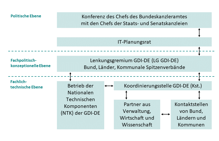
The Spatial Data Infrastructure Germany (GDI-DE) is coordinated jointly by the federal level, the federal states and municipalities. Its central bodies are:
- the Steering Committee SDI Germany (Lenkungsgremium GDIDE)
- the Coordination Office SDI Germany (Koordinierungsstelle GDIDE) and
- the Operation Office SDI Germany (Betrieb GDI-DE), which operates the national technical components of the GDI-DE:
- spatial data catalogue (Geodatenkatalog.de)
- geoportal (Geoportal.de)
- registry (GDI-DE Registry)
- validation tool (GDI-DE Testsuite)
- monitoring tool (GDI-DE Monitor)
Cooperation with the private sector is ensured by regular meetings of an advisory board consisting of representatives of business associations, among others (Advisory Committee SDI Germany).
Cooperation with the scientific sector is ensured by participation of GDI-DE in the national research data infrastructure (NFDI4Earth).
Scientific representatives are also represented in the Steering Committee SDI Germany as observers.
On request of the Conference of Environmental Ministers (Umweltministerkonferenz, UMK), a Working Group of the SDI Germany aims to:
- contribute the view point of the UMK working groups to the further development of the GDI-DE,
- coordinate the further development of INSPIRE and other environmental thematic legislation.
The chair of Steering Committee SDI Germany meets with representatives of the relevant Conferences of specialised state ministers twice a year to facilitate domain-specific communication.
Progress
The structures already established in 2013 have proven to be successful and will be continued based on the administrative arrangement between the federal state (Bund) and the federal states (Laender) for the creation and operation of the GDI-DE.
In addition, cooperation was intensified by the above mentioned meetings with representatives of the Conferences of specialised state ministers.
The integration into „Maintenance and Implementation Framework“ has established a closer cooperation with other Member States.
The cooperation between different administrations has been improved through the creation of a web-based collaboration platform (GDI-DE Wiki).
In the context of developing guidance for the implementation of the Implementing Act on High-value Datasets, the Coordination Office and Working Groups have actively contributed to the FAQ pages for data providers on the GovData portal.
Functioning and coordination of the infrastructure
INSPIRE is embedded in the National Spatial Data Strategy (NGIS) adopted by the Steering Committee GDI-DE in 2015 and acknowledged as an important addition to the National e-Government Strategy. The strategy shall ensure that spatial information can be effectively used for all spatially relevant decision making processes, including to serve local and national interests. The strategy identifies key principles such as
- Supply of high quality basic spatial data,
- Foster the multiple use of spatial data and
- Promote innovations in spatial data management.
The coordination of the infrastructure has been further improved through
- intensified discussions with the GI industry, the municipal umbrella associations and Conferences of specialised state ministers;
- new working groups on SDIs/INSPIRE under the Conferences of specialised state ministers;
- a growing number of workshops with INSPIRE points of contact.
To facilitate data and service sharing and use, a joint architecture concept has been developed, based on the INSPIRE Directive, Implementing Rules and Technical Guidance documents. National technical components of the GDI-DE include a spatial data catalogue (Geodatenkatalog.de), geoportal (Geoportal.de), registry (GDI-DE Registry), validator (GDI-DE Testsuite) and monitoring tool (GDI-DE Monitor).
Usage of the infrastructure for spatial information
Both public administrations and the private sector are still not widely using the INSPIRE infrastructure to access and use spatial data, mainly because their public tasks are at the local or regional level. But the importance of a (regional or national) spatial data infrastructure is constantly increasing. More and more processes are based on this kind of data platform.
The documentation of spatial data sets and services through metadata has however made people more aware of the spatial data available in public administration and has thus improved data sharing and use through conventional methods or OGC services. It has also led to an increase in data being made available in digital form.
In the light of recital 6 and 27 of the INSPIRE Directive and to improve domain-specific access and transparency on INSPIRE data sets, the responsible administrations in some thematic domains have agreed on providing national data on a national level, e.g.
- in the water domain, the Federal Institute for Hydrography (BfG) provides data for the Flood Directive, Water Framework Directive, Bathing Water Directive and Marine Strategy Framework Directive (overview INSPIRE services)
- in the geology domain, the Federal Institute for Geosciences and Natural Ressources (BGR) and the state geological surveys have agreed that the INSPIRE harmonisation of the German borehole data will be carried out by BGR for 14 of the 16 German states
- in the air quality domain, the Federal Environmental Agency (UBA) was mandated by the federal states to provide data asked for in the Air Quality Directive and
- in the soil domain, the Federal Environmental Agency (UBA) was mandated by the federal states to provide data of the permant soil observation.
Some public administrations, in particular at the local level, are still struggling with implementing INSPIRE themselves, due to the perceived complexity of the INSPIRE rules and the related standards and technologies.
In addition, there are currently still few products on the market that allow the processing of INSPIRE-conformant data, and such functionalities are only rarely required by users. There are therefore only few application examples that go beyond the state of a pilot study.
Data sets provided in legacy data models via INSPIRE compliant network services published in regional, state and national geoportals, on the other hand, are often widely used.
Data Sharing Arrangements
Individual, bi- or multi-lateral data sharing agreements are increasingly being replaced by generic, legally based conditions for the access to public sector data. This is reflected in an increasing number of legislation on e-Government, Open Data and transparency.
According to federal laws, environmental (UIG) and particular spatial data (GeoZG) are publicly available and, for federal data, free of charge.
Selected spatial reference data of the federal states are provided (against payment) through a common national access point.
The main barrier for data sharing and use are not the existing data sharing arrangements, but rather the INSPIRE data models, some of which are perceived as too simple and some as too complex and not fitting the user requirements, as well as the lack of tools for using INSPIRE data.
Costs and Benefits
After initially high investment in the creation and operation of the national INSPIRE infrastructure, the costs for the operation of the national technical components have been kept stable at a high level since 2016. This does not consider the costs for the creation of the increasing number of INSPIRE compliant data and services by the relevant data providers.
A reliable evaluation of the cost-benefit ratio will only become possible, when INSPIRE compliant data and services are more widely available and used.